
Topografische kaart Saluda
Interactieve kaart
Klik op de kaart om de hoogte weer te geven.
Saluda
Saluda is located in southwestern Polk County. Two small parts of the city extend west and north into Henderson County. The elevation on Main Street is 2,097 feet (639 m) above sea level, while the elevation at the bottom end of the Saluda Grade, in Tryon, is 1,080 feet (329.1 m).
Over deze kaart
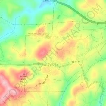
Naam: Topografische kaart Saluda, hoogte, reliëf.
Locatie: Saluda, Polk County, North Carolina, 28773, United States (35.22812 -82.36302 35.25086 -82.32559)
Gemiddelde hoogte: 635 m
Minimale hoogte: 498 m
Maximale hoogte: 735 m