
Topografische kaart Ischigualasto Provincial Park
Interactieve kaart
Klik op de kaart om de hoogte weer te geven.
Over deze kaart
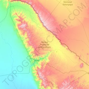
Naam: Topografische kaart Ischigualasto Provincial Park, hoogte, reliëf.
Gemiddelde hoogte: 1.258 m
Minimale hoogte: 758 m
Maximale hoogte: 1.929 m
Most of the park lies within the Valle Fértil Department, with a minor part in the Jachal Department of San Juan, at an altitude of about 1,300 m (4,300 ft) amsl. The park is part of the western border of the Central Sierras, and it features typical desert vegetation (bushes, cacti and some trees) which covers between 10 and 20% of the area. The climate is very dry, with rainfall mostly during the summer, and temperature extremes (minimum −10 °C or 14 °F, maximum 45 °C or 113 °F). There is a constant southern wind with a speed of 20–40 km/h (12–25 mph) after noon and until the evening, sometimes accompanied by the extremely strong Zonda wind.
Andere topografische kaarten
Klik op een kaart om zijn topografie, zijn hoogte en zijn reliëf te bekijken.
Villa San Andrés
Villa San Andrés, Capital, San Juan, Argentina
Gemiddelde hoogte: 661 m
Quebrada Seca
Quebrada Seca, Iglesia, San Juan, Argentina
Gemiddelde hoogte: 4.334 m
Hediondo (o Rincón del Diablo)
Hediondo (o Rincón del Diablo), Iglesia, San Juan, Argentina
Gemiddelde hoogte: 4.025 m
Parkinson Hill
Parkinson Hill, Zonda, San Juan, 5478, Argentina
Gemiddelde hoogte: 1.336 m
Quebrada Seca
Quebrada Seca, Calingasta, San Juan, Argentina
Gemiddelde hoogte: 3.106 m
Cerro Mercedario
Cerro Mercedario, Calingasta, San Juan, Argentina
Gemiddelde hoogte: 6.128 m