
Topografische kaart Eureka
Interactieve kaart
Klik op de kaart om de hoogte weer te geven.
Over deze kaart
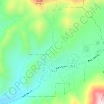
Naam: Topografische kaart Eureka, hoogte, reliëf.
Locatie: Eureka, Juab County, Utah, United States (39.94749 -112.12847 39.97063 -112.09986)
Gemiddelde hoogte: 2.048 m
Minimale hoogte: 1.894 m
Maximale hoogte: 2.396 m
Eureka is located in northern Juab County at 39°57′18″N 112°6′59″W / 39.95500°N 112.11639°W / 39.95500; -112.11639 (39.954974, -112.116364). It sits in the East Tintic Mountains at an elevation of 6,430 feet (1,960 m) above sea level. The northeast boundary of the city is the Utah County line, following the height of land. 7,828-foot (2,386 m) Packard Peak is to the north, while 8,048-foot (2,453 m) Godiva Mountain and 7,917-foot (2,413 m) Eureka Ridge are to the south.
Andere topografische kaarten
Klik op een kaart om zijn topografie, zijn hoogte en zijn reliëf te bekijken.
Desert Mountain
United States > Utah > Juab County
Desert Mountain, Juab County, Utah, United States
Gemiddelde hoogte: 1.673 m
Topaz Mountain
United States > Utah > Juab County
Topaz Mountain, Juab County, Utah, United States
Gemiddelde hoogte: 1.895 m
Nephi
United States > Utah > Juab County > Nephi
Nephi, Juab County, Utah, 84648, United States
Gemiddelde hoogte: 1.651 m
Nephi
United States > Utah > Juab County
Nephi, Juab County, Utah, 84648, United States
Gemiddelde hoogte: 1.637 m