
Topografische kaart Inyokern
Interactieve kaart
Klik op de kaart om de hoogte weer te geven.
Over deze kaart
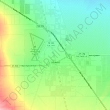
Naam: Topografische kaart Inyokern, hoogte, reliëf.
Locatie: Inyokern, Kern County, California, United States (35.62268 -117.87212 35.68164 -117.77582)
Gemiddelde hoogte: 749 m
Minimale hoogte: 703 m
Maximale hoogte: 842 m
Inyokern (formerly Siding 16 and Magnolia) is a census-designated place (CDP) in Kern County, California, United States. Its name derives from its location near the border between Inyo and Kern Counties. Inyokern is located 8 miles (13 km) west of Ridgecrest, at an elevation of 2,434 feet (742 m). It is on the western side of the Indian Wells Valley. The population was 988 in the 2020 census, down from 1,099 in the 2010 census. It was a railroad town established along the Southern Pacific railroad's Lone Pine Branch (now removed) and with WWII became site of the Naval Air Weapons Station China Lake.
Andere topografische kaarten
Klik op een kaart om zijn topografie, zijn hoogte en zijn reliëf te bekijken.
Rosedale
United States > California > Kern County
Rosedale, Kern County, California, United States
Gemiddelde hoogte: 113 m
Upper Richbar Picnic Area
United States > California > Kern County
Upper Richbar Picnic Area, Kern County, California, United States
Gemiddelde hoogte: 658 m
Wasco
United States > California > Kern County
Wasco, Kern County, California, United States
Gemiddelde hoogte: 101 m
Mojave
United States > California > Kern County
Mojave, Kern County, California, United States
Gemiddelde hoogte: 857 m
Baker
United States > California > Kern County > Boron
Baker, Boron, Kern County, California, United States
Gemiddelde hoogte: 765 m
Rosedale
United States > California > Kern County
Rosedale, Kern County, CAL Fire Contract Counties, California, United States
Gemiddelde hoogte: 107 m
Ridgecrest
United States > California > Kern County
Ridgecrest, Kern County, California, 93555, United States
Gemiddelde hoogte: 740 m
Lake Isabella
United States > California > Kern County
Lake Isabella, Kern County, California, United States
Gemiddelde hoogte: 979 m
Boron
United States > California > Kern County > Boron
Boron, Kern County, California, United States
Gemiddelde hoogte: 753 m
Tehachapi
United States > California > Kern County
Tehachapi, Kern County, California, 93561, United States
Gemiddelde hoogte: 1.414 m
Cameron
United States > California > Kern County
Cameron, Kern County, California, United States
Gemiddelde hoogte: 1.309 m
Rio Bravo
United States > California > Kern County
Rio Bravo, Kern County, California, United States
Gemiddelde hoogte: 97 m
Bakersfield
United States > California > Kern County
Bakersfield, Kern County, California, United States
Gemiddelde hoogte: 157 m