
Topografische kaart LaFollette
Interactieve kaart
Klik op de kaart om de hoogte weer te geven.
LaFollette
According to the United States Census Bureau, the city has a total area of 4.9 sq mi (12.7 km2), all land. The elevation varies around the city, around 1,050 ft (320 m) in the valley areas to 1,500 ft (460 m) on ridge tops. The average elevation is around 1,150 ft (350 m).
Over deze kaart
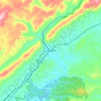
Naam: Topografische kaart LaFollette, hoogte, reliëf.
Gemiddelde hoogte: 435 m
Minimale hoogte: 301 m
Maximale hoogte: 726 m