
Topografische kaart Kampung Pantai
Interactieve kaart
Klik op de kaart om de hoogte weer te geven.
Over deze kaart
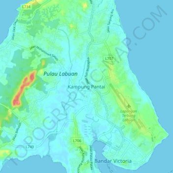
Naam: Topografische kaart Kampung Pantai, hoogte, reliëf.
Locatie: Kampung Pantai, Labuan, 87000, Malaysia (5.27137 115.19100 5.35137 115.27100)
Gemiddelde hoogte: 10 m
Minimale hoogte: 0 m
Maximale hoogte: 70 m
Andere topografische kaarten
Klik op een kaart om zijn topografie, zijn hoogte en zijn reliëf te bekijken.
Daat Island
Malaysia > Labuan > Labuan > Victoria
Daat Island, Victoria, Labuan, Malaysia
Gemiddelde hoogte: 5 m
Taman Awam Pantai Tanjung Purun
Malaysia > Labuan > Labuan > Victoria
Taman Awam Pantai Tanjung Purun, Victoria, Labuan, Malaysia
Gemiddelde hoogte: 4 m
Labuan Bird Park
Malaysia > Labuan > Kampung Pohon Batu
Labuan Bird Park, Kampung Pohon Batu, Labuan, 87000, Malaysia
Gemiddelde hoogte: 13 m
Kampung Patau-Patau II (Water Village)
Kampung Patau-Patau II (Water Village), Victoria, Labuan, 87009, Malaysia
Gemiddelde hoogte: 7 m