
Topografische kaart Somerset
Interactieve kaart
Klik op de kaart om de hoogte weer te geven.
Over deze kaart
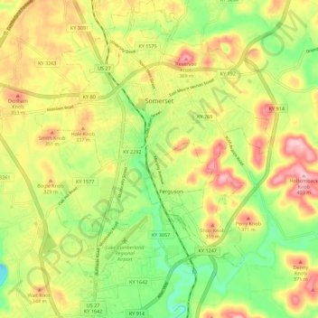
Naam: Topografische kaart Somerset, hoogte, reliëf.
Locatie: Somerset, Pulaski County, Kentucky, 42503, United States (37.03135 -84.64756 37.12006 -84.56484)
Gemiddelde hoogte: 295 m
Minimale hoogte: 202 m
Maximale hoogte: 398 m
Somerset is located at 37°4′59″N 84°36′34″W / 37.08306°N 84.60944°W / 37.08306; -84.60944 (37.082966, −84.609387),[7] and the downtown (central) part of the city is at an elevation of 974 feet above sea level. The city is located at the eastern end of Kentucky's Mississippian Plateau (or Pennyroyal Plateau); however, the micropolitan area extends eastward into the Appalachian Plateau (or Eastern Kentucky Coalfield), and northward to Kentucky's Outer Bluegrass region. Thus, the area shows significant variations in landforms and scenery.
Andere topografische kaarten
Klik op een kaart om zijn topografie, zijn hoogte en zijn reliëf te bekijken.
Bronston
United States > Kentucky > Pulaski County
Bronston, Pulaski County, Kentucky, 42518, United States
Gemiddelde hoogte: 248 m
Drum
United States > Kentucky > Pulaski County
Drum, Pulaski County, Kentucky, United States
Gemiddelde hoogte: 332 m