
Topografische kaart Ellwood
Interactieve kaart
Klik op de kaart om de hoogte weer te geven.
Over deze kaart
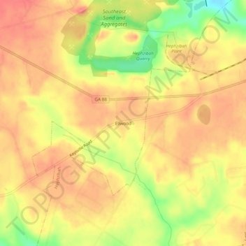
Naam: Topografische kaart Ellwood, hoogte, reliëf.
Locatie: Ellwood, Augusta, Richmond County, Georgia, United States (33.28431 -82.14929 33.32431 -82.10929)
Gemiddelde hoogte: 119 m
Minimale hoogte: 73 m
Maximale hoogte: 142 m
Andere topografische kaarten
Klik op een kaart om zijn topografie, zijn hoogte en zijn reliëf te bekijken.
Augusta Canal
United States > Georgia > Richmond County > Augusta
Augusta Canal, Augusta, Richmond County, Georgia, United States
Gemiddelde hoogte: 80 m
Dorchester
United States > Georgia > Richmond County > Augusta
Dorchester, Augusta, Richmond County, Georgia, 30909, United States
Gemiddelde hoogte: 90 m
Forest Acres
United States > Georgia > Richmond County > Augusta
Forest Acres, Augusta, Richmond County, Georgia, 30904, United States
Gemiddelde hoogte: 67 m
Fairvale
United States > Georgia > Richmond County > Augusta
Fairvale, Augusta, Richmond County, Georgia, 30906, United States
Gemiddelde hoogte: 56 m
Berckman Villas
United States > Georgia > Richmond County > Augusta > Berckman Villas
Berckman Villas, Augusta, Richmond County, Georgia, 30904, United States
Gemiddelde hoogte: 87 m
Fort Gordon
United States > Georgia > Richmond County > Augusta > Fort Gordon
Fort Gordon, Augusta, Richmond County, Georgia, 30905, United States
Gemiddelde hoogte: 136 m