
Topografische kaart Springfield
Interactieve kaart
Klik op de kaart om de hoogte weer te geven.
Over deze kaart
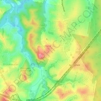
Naam: Topografische kaart Springfield, hoogte, reliëf.
Locatie: Springfield, Ipswich City, Queensland, 4300, Australia (-27.67459 152.89350 -27.63686 152.92472)
Gemiddelde hoogte: 62 m
Minimale hoogte: 20 m
Maximale hoogte: 109 m
Andere topografische kaarten
Klik op een kaart om zijn topografie, zijn hoogte en zijn reliëf te bekijken.
Brookwater
Australia > Queensland > Ipswich City
Brookwater, Ipswich City, Queensland, Australia
Gemiddelde hoogte: 56 m
Rosewood
Australia > Queensland > Ipswich City
Rosewood, Ipswich City, Queensland, Australia
Gemiddelde hoogte: 71 m
Redbank
Australia > Queensland > Ipswich City
Redbank, Ipswich City, Queensland, Australia
Gemiddelde hoogte: 27 m
Redbank Plains
Australia > Queensland > Ipswich City
Redbank Plains, Ipswich City, Queensland, 4301, Australia
Gemiddelde hoogte: 68 m
Mutdapilly
Australia > Queensland > Ipswich City
Mutdapilly, Ipswich City, Queensland, Australia
Gemiddelde hoogte: 55 m
Haigslea
Australia > Queensland > Ipswich City
Haigslea, Ipswich City, Queensland, Australia
Gemiddelde hoogte: 87 m