
Doe een donatie
Rust jezelf uit voor je volgende avontuur:
Als Amazon-partner verdient deze site een commissie op in aanmerking komende aankopen, zonder extra kosten voor jou.
Topografische kaart Wraysbury
Klik op de kaart om de hoogte weer te geven.
Doe een donatie
Rust jezelf uit voor je volgende avontuur:
Als Amazon-partner verdient deze site een commissie op in aanmerking komende aankopen, zonder extra kosten voor jou.
Wraysbury
The new chapel, with its elegant slender tower, was opened on 16 October 1862; the building works had cost around £800. The striking terracotta relief panel, The City of Refuge, on the front elevation of the chapel, was created by the renowned Doulton & Co artist George Tinworth and is signed with his monogram. After Buckland's death, James Doulton, his son-in-law and a cousin of Sir Henry Doulton, took over the preaching duties. Later James' son-in-law the Reverend Arthur Gostick Shorrock took over the duties. Arthur had been a student preacher in Wraysbury in the 1880s, after which he spent 35 years as a missionary in Shaanxi, China.
Doe een donatie
Rust jezelf uit voor je volgende avontuur:
Als Amazon-partner verdient deze site een commissie op in aanmerking komende aankopen, zonder extra kosten voor jou.
Over deze kaart
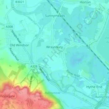
Naam: Topografische kaart Wraysbury, hoogte, reliëf.
Gemiddelde hoogte: 26 m
Minimale hoogte: 10 m
Maximale hoogte: 90 m
Doe een donatie
Rust jezelf uit voor je volgende avontuur:
Als Amazon-partner verdient deze site een commissie op in aanmerking komende aankopen, zonder extra kosten voor jou.
Andere topografische kaarten
Klik op een kaart om zijn topografie, zijn hoogte en zijn reliëf te bekijken.
Windsor Marina
United Kingdom > England > Royal Borough of Windsor and Maidenhead > Oakley Green
Gemiddelde hoogte: 26 m
Silwood Park
United Kingdom > England > Royal Borough of Windsor and Maidenhead > Beggar's Bush
Gemiddelde hoogte: 61 m
Doe een donatie
Rust jezelf uit voor je volgende avontuur:
Als Amazon-partner verdient deze site een commissie op in aanmerking komende aankopen, zonder extra kosten voor jou.
Braywoodside
United Kingdom > England > Royal Borough of Windsor and Maidenhead
Gemiddelde hoogte: 43 m
Sunninghill
United Kingdom > England > Royal Borough of Windsor and Maidenhead
Gemiddelde hoogte: 67 m
Magna Carta Island
United Kingdom > England > Royal Borough of Windsor and Maidenhead > Wraysbury
Gemiddelde hoogte: 32 m
Doe een donatie
Rust jezelf uit voor je volgende avontuur:
Als Amazon-partner verdient deze site een commissie op in aanmerking komende aankopen, zonder extra kosten voor jou.
Cookham Dean
United Kingdom > England > Royal Borough of Windsor and Maidenhead
Gemiddelde hoogte: 50 m
Bridge Gardens
United Kingdom > England > Royal Borough of Windsor and Maidenhead > Maidenhead
Gemiddelde hoogte: 30 m
Upton Court Park
United Kingdom > England > Royal Borough of Windsor and Maidenhead > Slough
Gemiddelde hoogte: 23 m
Doe een donatie
Rust jezelf uit voor je volgende avontuur:
Als Amazon-partner verdient deze site een commissie op in aanmerking komende aankopen, zonder extra kosten voor jou.
Formosa Island
United Kingdom > England > Royal Borough of Windsor and Maidenhead > Cookham
Gemiddelde hoogte: 48 m
Burchett's Green
United Kingdom > England > Royal Borough of Windsor and Maidenhead > Hurley
Gemiddelde hoogte: 68 m
Windsor Castle
United Kingdom > England > Royal Borough of Windsor and Maidenhead > Windsor > Clewer Village
Gemiddelde hoogte: 23 m
Doe een donatie
Rust jezelf uit voor je volgende avontuur:
Als Amazon-partner verdient deze site een commissie op in aanmerking komende aankopen, zonder extra kosten voor jou.
Oakley Green
United Kingdom > England > Royal Borough of Windsor and Maidenhead
Gemiddelde hoogte: 37 m
Cookham Rise
United Kingdom > England > Royal Borough of Windsor and Maidenhead
Gemiddelde hoogte: 44 m
Doe een donatie
Rust jezelf uit voor je volgende avontuur:
Als Amazon-partner verdient deze site een commissie op in aanmerking komende aankopen, zonder extra kosten voor jou.
Cookham Rise
United Kingdom > England > Royal Borough of Windsor and Maidenhead
Gemiddelde hoogte: 44 m
Windsor Castle
United Kingdom > England > Royal Borough of Windsor and Maidenhead > Windsor > Clewer Village
Gemiddelde hoogte: 23 m
Windsor Castle
United Kingdom > England > Royal Borough of Windsor and Maidenhead > Windsor > Clewer Village
Gemiddelde hoogte: 23 m
Windsor Castle
United Kingdom > England > Royal Borough of Windsor and Maidenhead > Windsor > Clewer Village
Gemiddelde hoogte: 23 m
Doe een donatie
Rust jezelf uit voor je volgende avontuur:
Als Amazon-partner verdient deze site een commissie op in aanmerking komende aankopen, zonder extra kosten voor jou.
Cookham Dean
United Kingdom > England > Royal Borough of Windsor and Maidenhead
Gemiddelde hoogte: 50 m
Doe een donatie
Rust jezelf uit voor je volgende avontuur:
Als Amazon-partner verdient deze site een commissie op in aanmerking komende aankopen, zonder extra kosten voor jou.