
Topografische kaart Bhilai
Interactieve kaart
Klik op de kaart om de hoogte weer te geven.
Over deze kaart
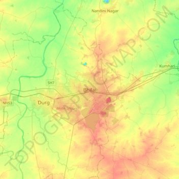
Naam: Topografische kaart Bhilai, hoogte, reliëf.
Locatie: Bhilai, Durg Tahsil, Durg, Chhattisgarh, 490023, India (21.05207 81.21328 21.37207 81.53328)
Gemiddelde hoogte: 292 m
Minimale hoogte: 255 m
Maximale hoogte: 335 m
Bhilai lies at 21.21°N 81.38°E in Central India at an elevation of 297m above sea level on the banks of the Shivnath river, a tributary of the river Mahanadi. It covers an area of 341 km2 (132 sq mi).
Andere topografische kaarten
Klik op een kaart om zijn topografie, zijn hoogte en zijn reliëf te bekijken.
Durg
India > Chhattisgarh > Durg Tahsil
Durg, Durg Tahsil, Durg District, Chhattisgarh, 491002, India
Gemiddelde hoogte: 295 m