
Topografische kaart Saint Stephen Parish
Interactieve kaart
Klik op de kaart om de hoogte weer te geven.
Over deze kaart
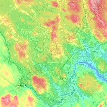
Naam: Topografische kaart Saint Stephen Parish, hoogte, reliëf.
Gemiddelde hoogte: 65 m
Minimale hoogte: -1 m
Maximale hoogte: 167 m
Andere topografische kaarten
Klik op een kaart om zijn topografie, zijn hoogte en zijn reliëf te bekijken.
St. George
Canada > New Brunswick > Charlotte County
St. George, Charlotte County, New Brunswick, Canada
Gemiddelde hoogte: 33 m
Beaver Harbour
Canada > New Brunswick > Charlotte County
Beaver Harbour, Charlotte County, New Brunswick, Canada
Gemiddelde hoogte: 25 m
Saint Andrews
Canada > New Brunswick > Charlotte County > Town of Saint Andrews > Saint Andrews
Saint Andrews, Town of Saint Andrews, Charlotte County, New Brunswick, E5B 1X7, Canada
Gemiddelde hoogte: 7 m
Deer Island
Canada > New Brunswick > Charlotte County > Deer Island
Deer Island, West Isles Parish, Charlotte County, New Brunswick, E5V 1W2, Canada
Gemiddelde hoogte: 9 m
Kerrs Lake
Canada > New Brunswick > Charlotte County
Kerrs Lake, Saint Patrick Parish, Charlotte County, New Brunswick, Canada
Gemiddelde hoogte: 87 m
Saint George Parish
Canada > New Brunswick > Charlotte County
Saint George Parish, Charlotte County, New Brunswick, Canada
Gemiddelde hoogte: 78 m
Hoyt Island
Canada > New Brunswick > Charlotte County
Hoyt Island, Saint George Parish, Charlotte County, New Brunswick, Canada
Gemiddelde hoogte: 7 m
St. Stephen
Canada > New Brunswick > Charlotte County > Saint Stephen
St. Stephen, Saint Stephen, Charlotte County, New Brunswick, E3L 1G2, Canada
Gemiddelde hoogte: 44 m
Johns Cove
Canada > New Brunswick > Charlotte County > Campobello Island
Johns Cove, North Road, Campobello Island, Campobello Parish, Charlotte County, New Brunswick, Canada
Gemiddelde hoogte: 20 m
Saint James Parish
Canada > New Brunswick > Charlotte County
Saint James Parish, Charlotte County, New Brunswick, Canada
Gemiddelde hoogte: 94 m
Saint Stephen
Canada > New Brunswick > Charlotte County
Saint Stephen, Charlotte County, New Brunswick, Canada
Gemiddelde hoogte: 44 m