
Topografische kaart Camels Hump
Interactieve kaart
Klik op de kaart om de hoogte weer te geven.
Over deze kaart
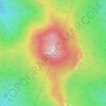
Naam: Topografische kaart Camels Hump, hoogte, reliëf.
Gemiddelde hoogte: 843 m
Minimale hoogte: 534 m
Maximale hoogte: 1.223 m
The summit of Camel's Hump is home to 10 acres (4 ha) of alpine tundra vegetation. Common plants found in this area include: Bigelow's sedge (Carex bigelowii), alpine bilberry (Vaccinium uliginosum), mountain sandwort (Minuartia groenlandica), crowberry (Empetrum nigrum), mountain cranberry (Vaccinium vitis-idaea), and Labrador tea (Rhododendron groenlandicum). A direct result of glacial formation, these alpine species were once widespread but as the lower elevations warmed, only the very peak of Camel's Hump remained hospitable to the fragile plants.
Andere topografische kaarten
Klik op een kaart om zijn topografie, zijn hoogte en zijn reliëf te bekijken.
Hanksville
United States > Vermont > Chittenden County > Huntington
Hanksville, Huntington, Chittenden County, Vermont, United States
Gemiddelde hoogte: 426 m