
Topografische kaart Prairie Creek Reservoir
Interactieve kaart
Klik op de kaart om de hoogte weer te geven.
Over deze kaart
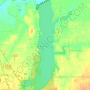
Naam: Topografische kaart Prairie Creek Reservoir, hoogte, reliëf.
Gemiddelde hoogte: 309 m
Minimale hoogte: 293 m
Maximale hoogte: 327 m
Andere topografische kaarten
Klik op een kaart om zijn topografie, zijn hoogte en zijn reliëf te bekijken.
Albany
United States > Indiana > Delaware County
Albany, Delaware County, Indiana, 47320, United States
Gemiddelde hoogte: 290 m
Oakville
United States > Indiana > Delaware County
Oakville, Delaware County, Indiana, 47367, United States
Gemiddelde hoogte: 309 m
Royerton
United States > Indiana > Delaware County
Royerton, Delaware County, Indiana, 47303, United States
Gemiddelde hoogte: 285 m
Gaston
United States > Indiana > Delaware County
Gaston, Delaware County, Indiana, United States
Gemiddelde hoogte: 273 m
Eaton
United States > Indiana > Delaware County
Eaton, Delaware County, Indiana, 47338, United States
Gemiddelde hoogte: 279 m
Cowan
United States > Indiana > Delaware County
Cowan, Delaware County, Indiana, 47367, United States
Gemiddelde hoogte: 303 m
Yorktown
United States > Indiana > Delaware County
Yorktown, Delaware County, Indiana, United States
Gemiddelde hoogte: 282 m
White River
United States > Indiana > Delaware County > Yorktown
White River, Yorktown, Delaware County, Indiana, United States
Gemiddelde hoogte: 282 m
Muncie
United States > Indiana > Delaware County
Muncie, Delaware County, Indiana, United States
Gemiddelde hoogte: 291 m
Selma
United States > Indiana > Delaware County
Selma, Delaware County, Indiana, United States
Gemiddelde hoogte: 304 m
Daleville
United States > Indiana > Delaware County
Daleville, Delaware County, Indiana, United States
Gemiddelde hoogte: 280 m
Muncie
United States > Indiana > Delaware County > Muncie
Muncie, Delaware County, Indiana, 47305, United States
Gemiddelde hoogte: 294 m
Creston
United States > Indiana > Delaware County > Muncie > Creston
Creston, Muncie, Delaware County, Indiana, 47303, United States
Gemiddelde hoogte: 292 m