
Topografische kaart Kinabalu Park
Interactieve kaart
Klik op de kaart om de hoogte weer te geven.
Kinabalu Park
The park headquarters is 88 kilometres away from the city of Kota Kinabalu. There are sealed roads leading towards the park headquarters from other parts of Sabah. It is situated on the southern boundary of Kinabalu Park, at an elevation of 1,563 m (5,128 ft).
Over deze kaart
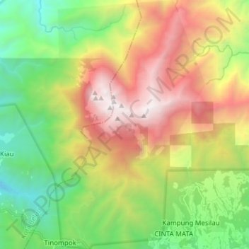
Naam: Topografische kaart Kinabalu Park, hoogte, reliëf.
Gemiddelde hoogte: 2.063 m
Minimale hoogte: 673 m
Maximale hoogte: 4.062 m