
Topografische kaart Glastonbury
Interactieve kaart
Klik op de kaart om de hoogte weer te geven.
Over deze kaart
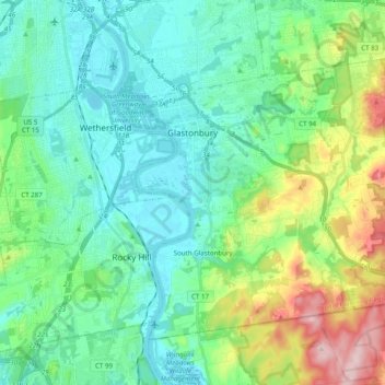
Naam: Topografische kaart Glastonbury, hoogte, reliëf.
Gemiddelde hoogte: 67 m
Minimale hoogte: 0 m
Maximale hoogte: 273 m
The town center experiences a humid continental climate (Dfa). However, the rural parts of the town, at an elevation of 800 feet near Bolton and Hebron, experience a colder climate which straddles the (Dfa) and (Dfb) lines.
Andere topografische kaarten
Klik op een kaart om zijn topografie, zijn hoogte en zijn reliëf te bekijken.
Mansfield
United States > Connecticut > Capitol Planning Region
Mansfield, Capitol Planning Region, Connecticut, United States
Gemiddelde hoogte: 130 m
West Hartford
United States > Connecticut > Capitol Planning Region
West Hartford, Capitol Planning Region, Connecticut, United States
Gemiddelde hoogte: 60 m
Whites Hill
United States > Connecticut > Capitol Planning Region > Bolton
Whites Hill, Bolton, Capitol Planning Region, Connecticut, 06043, United States
Gemiddelde hoogte: 205 m
South Windsor
United States > Connecticut > Capitol Planning Region
South Windsor, Capitol Planning Region, Connecticut, United States
Gemiddelde hoogte: 42 m
Hartford County
United States > Connecticut > Capitol Planning Region
Hartford County, Capitol Planning Region, Connecticut, United States
Gemiddelde hoogte: 122 m