
Topografische kaart Fountain Hill
Interactieve kaart
Klik op de kaart om de hoogte weer te geven.
Over deze kaart
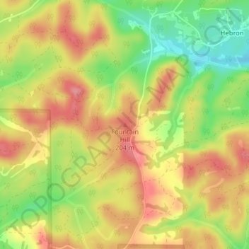
Naam: Topografische kaart Fountain Hill, hoogte, reliëf.
Locatie: Fountain Hill, Bibb County, Alabama, United States (33.15729 -87.08116 33.15739 -87.08106)
Gemiddelde hoogte: 166 m
Minimale hoogte: 113 m
Maximale hoogte: 205 m
Andere topografische kaarten
Klik op een kaart om zijn topografie, zijn hoogte en zijn reliëf te bekijken.
East Centreville
United States > Alabama > Bibb County > Centreville
East Centreville, Centreville, Bibb County, Alabama, 35042, United States
Gemiddelde hoogte: 77 m
Lawley
United States > Alabama > Bibb County
Lawley, Bibb County, Alabama, 35793, United States
Gemiddelde hoogte: 139 m
Centreville
United States > Alabama > Bibb County
Centreville, Bibb County, Alabama, 35042, United States
Gemiddelde hoogte: 93 m
Tucker
United States > Alabama > Bibb County > Tucker
Tucker, Bibb County, Alabama, United States
Gemiddelde hoogte: 150 m
Randolph
United States > Alabama > Bibb County > Randolph
Randolph, Bibb County, Alabama, United States
Gemiddelde hoogte: 162 m
Schultz Creek
United States > Alabama > Bibb County
Schultz Creek, Bibb County, Alabama, United States
Gemiddelde hoogte: 115 m
Sand Mountain
United States > Alabama > Bibb County
Sand Mountain, Bibb County, Alabama, United States
Gemiddelde hoogte: 156 m
Brent
United States > Alabama > Bibb County > Brent
Brent, Bibb County, Alabama, 35034, United States
Gemiddelde hoogte: 84 m