
Topografische kaart Cumberland Gap
Interactieve kaart
Klik op de kaart om de hoogte weer te geven.
Cumberland Gap
The Cumberland Gap is a pass in the eastern United States through the long ridge of the Cumberland Mountains, within the Appalachian Mountains and near the tripoint of Kentucky, Virginia, and Tennessee. At an elevation of 1,631 feet (497 m) above sea level, it is famous in American colonial history for its role as a key passageway through the lower central Appalachians.
Over deze kaart
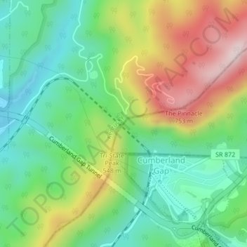
Naam: Topografische kaart Cumberland Gap, hoogte, reliëf.
Locatie: Cumberland Gap, Lee County, Virginia, 37724, United States (36.60399 -83.67369 36.60409 -83.67359)
Gemiddelde hoogte: 512 m
Minimale hoogte: 349 m
Maximale hoogte: 783 m
Andere topografische kaarten
Klik op een kaart om zijn topografie, zijn hoogte en zijn reliëf te bekijken.