
Doe een donatie
Rust jezelf uit voor je volgende avontuur:
Als Amazon-partner verdient deze site een commissie op in aanmerking komende aankopen, zonder extra kosten voor jou.
Topografische kaart McHenry
Klik op de kaart om de hoogte weer te geven.
Doe een donatie
Rust jezelf uit voor je volgende avontuur:
Als Amazon-partner verdient deze site een commissie op in aanmerking komende aankopen, zonder extra kosten voor jou.
McHenry
It rests at an elevation of 797 feet and the Fox River flows through the eastern portion of the city. It is surrounded by natural lakes and streams, grassy moraine hills, gravel banks and shallow nutrient-rich peat bogs, remnants of receding glaciers from the last ice age. Moraine Hills State Park, Glacial Park Conservation Area, and Volo Bog State Natural Area preserve some of these natural features.
Doe een donatie
Rust jezelf uit voor je volgende avontuur:
Als Amazon-partner verdient deze site een commissie op in aanmerking komende aankopen, zonder extra kosten voor jou.
Over deze kaart
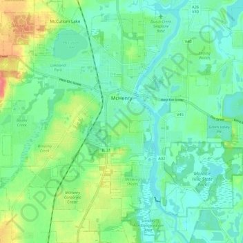
Naam: Topografische kaart McHenry, hoogte, reliëf.
Locatie: McHenry, McHenry County, Illinois, 60050, United States (42.29938 -88.34578 42.37125 -88.23793)
Gemiddelde hoogte: 237 m
Minimale hoogte: 218 m
Maximale hoogte: 282 m
Doe een donatie
Rust jezelf uit voor je volgende avontuur:
Als Amazon-partner verdient deze site een commissie op in aanmerking komende aankopen, zonder extra kosten voor jou.
Andere topografische kaarten
Klik op een kaart om zijn topografie, zijn hoogte en zijn reliëf te bekijken.
Riley
United States > Illinois > McHenry County
Riley, elevation 807 feet (246 m), is an unincorporated community and census-designated place in McHenry County, Illinois, United States. It was named a CDP before the 2020 census, at which time it had a population of 10.
Gemiddelde hoogte: 250 m
Doe een donatie
Rust jezelf uit voor je volgende avontuur:
Als Amazon-partner verdient deze site een commissie op in aanmerking komende aankopen, zonder extra kosten voor jou.