
Topografische kaart Mineral Point
Interactieve kaart
Klik op de kaart om de hoogte weer te geven.
Over deze kaart
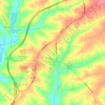
Naam: Topografische kaart Mineral Point, hoogte, reliëf.
Locatie: Mineral Point, Iowa County, Wisconsin, United States (42.84333 -90.21007 42.88394 -90.15772)
Gemiddelde hoogte: 324 m
Minimale hoogte: 275 m
Maximale hoogte: 364 m
Mineral Point was settled in 1827, becoming a lead and zinc mining center, and commercial town in the 19th and early 20th centuries. In the mid-20th century it attracted artists and an artist's colony and its tourism industry began to grow. The city's well-preserved historical character within the varied natural topography of the driftless area has made it a regional tourist destination. Mineral Point is sometimes called Wisconsin's third oldest city, but the Wisconsin Historical Society notes several older colonial settlements.
Andere topografische kaarten
Klik op een kaart om zijn topografie, zijn hoogte en zijn reliëf te bekijken.
Jonesdale
United States > Wisconsin > Iowa County
Jonesdale, Town of Waldwick, Iowa County, Wisconsin, United States
Gemiddelde hoogte: 306 m
Linden
United States > Wisconsin > Iowa County
Linden, Iowa County, Wisconsin, 53553, United States
Gemiddelde hoogte: 332 m
Cobb
United States > Wisconsin > Iowa County
Cobb, Iowa County, Wisconsin, 53526, United States
Gemiddelde hoogte: 359 m
Rewey
United States > Wisconsin > Iowa County
Rewey, Iowa County, Wisconsin, United States
Gemiddelde hoogte: 333 m
Highland
United States > Wisconsin > Iowa County
Highland, Iowa County, Wisconsin, United States
Gemiddelde hoogte: 353 m
Arena
United States > Wisconsin > Iowa County
Arena, Iowa County, Wisconsin, United States
Gemiddelde hoogte: 230 m
Montfort Junction
United States > Wisconsin > Iowa County
Montfort Junction, Town of Eden, Iowa County, Wisconsin, 53569, United States
Gemiddelde hoogte: 356 m
Edmund
United States > Wisconsin > Iowa County
Edmund, Town of Linden, Iowa County, Wisconsin, 53535, United States
Gemiddelde hoogte: 351 m
Avoca
United States > Wisconsin > Iowa County
Avoca, Iowa County, Wisconsin, United States
Gemiddelde hoogte: 217 m
Town of Mineral Point
United States > Wisconsin > Iowa County
Town of Mineral Point, Iowa County, Wisconsin, 53565, United States
Gemiddelde hoogte: 335 m
Governor Dodge State Park
United States > Wisconsin > Iowa County
Governor Dodge State Park, Town of Dodgeville, Iowa County, Wisconsin, 53533, United States
Gemiddelde hoogte: 336 m
Tower Hill State Park
United States > Wisconsin > Iowa County > Town of Wyoming
Tower Hill State Park, Town of Wyoming, Iowa County, Wisconsin, United States
Gemiddelde hoogte: 233 m
Town of Brigham
United States > Wisconsin > Iowa County
Town of Brigham, Iowa County, Wisconsin, 53507, United States
Gemiddelde hoogte: 330 m
Blue Mound State Park
United States > Wisconsin > Iowa County > Village of Blue Mounds
Blue Mound State Park, Village of Blue Mounds, Town of Brigham, Iowa County, Wisconsin, 53517, United States
Gemiddelde hoogte: 416 m
Town of Wyoming
United States > Wisconsin > Iowa County
Town of Wyoming, Iowa County, Wisconsin, United States
Gemiddelde hoogte: 267 m
Ridgeway
United States > Wisconsin > Iowa County
Ridgeway, Iowa County, Wisconsin, United States
Gemiddelde hoogte: 338 m
Town of Moscow
United States > Wisconsin > Iowa County
Town of Moscow, Iowa County, Wisconsin, 53544, United States
Gemiddelde hoogte: 293 m
Blue Mounds
United States > Wisconsin > Iowa County
Blue Mounds, Town of Brigham, Iowa County, Wisconsin, 53517, United States
Gemiddelde hoogte: 417 m
Barneveld
United States > Wisconsin > Iowa County
Barneveld, Iowa County, Wisconsin, United States
Gemiddelde hoogte: 350 m
Dodgeville
United States > Wisconsin > Iowa County
Dodgeville, Iowa County, Wisconsin, United States
Gemiddelde hoogte: 369 m
Hollandale
United States > Wisconsin > Iowa County
Hollandale, Iowa County, Wisconsin, United States
Gemiddelde hoogte: 278 m