
Topografische kaart Kidapawan
Interactieve kaart
Klik op de kaart om de hoogte weer te geven.
Over deze kaart
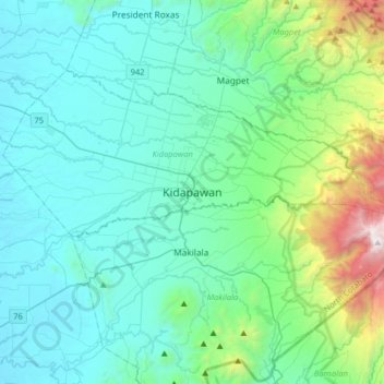
Naam: Topografische kaart Kidapawan, hoogte, reliëf.
Locatie: Kidapawan, North Cotabato, Soccsksargen, 9400, Philippines (6.84958 124.93050 7.16958 125.25050)
Gemiddelde hoogte: 442 m
Minimale hoogte: 30 m
Maximale hoogte: 2.603 m
Located in Kidapawan is the Paniki Falls Eco-River Park located at Umpan Village, Barangay Balabag. Kidapawan is also one of the most well-known starting points for trekking on Mount Apo via the city's Lake Agco in Barangay Ilomavis, Kidapawan-Santa Cruz, and Kidapawan-Magpet trails which towers at 10,311 feet (3,143 m) above sea level with a total area of 14.6 square metres (157 sq ft). The country's tallest peak is an abode to the almost extinct Philippine eagle. Within the Mt. Apo Natural Park is the Mandarangan Geological Site which is being promoted as a major educational tourism site. Lake Venado, hidden among the mountain ranges, stands at an elevation of 7,200 feet (2,200 m) above sea level.