
Topografische kaart Boyle Municipal District
Interactieve kaart
Klik op de kaart om de hoogte weer te geven.
Over deze kaart
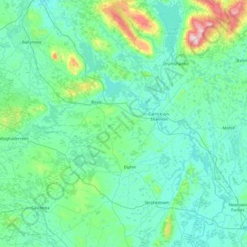
Naam: Topografische kaart Boyle Municipal District, hoogte, reliëf.
Locatie: Boyle Municipal District, County Roscommon, Connacht, Ireland (53.73304 -8.69153 54.12524 -7.87588)
Gemiddelde hoogte: 94 m
Minimale hoogte: 26 m
Maximale hoogte: 584 m
Andere topografische kaarten
Klik op een kaart om zijn topografie, zijn hoogte en zijn reliëf te bekijken.
Lisacul
Lisacul, Roscommon Municipal District, County Roscommon, Connacht, Ireland
Gemiddelde hoogte: 82 m
Ballaghaderreen
Ballaghaderreen, Ballaghaderreen ED, Boyle Municipal District, County Roscommon, Connacht, F45 XT73, Ireland
Gemiddelde hoogte: 84 m
Culleenatreen
Culleenatreen, Danesfort ED, Boyle Municipal District, County Roscommon, Connacht, Ireland
Gemiddelde hoogte: 65 m
Curraghboy
Curraghboy, Rockhill Electoral Division, Athlone Municipal District, County Roscommon, Connacht, N37 EK20, Ireland
Gemiddelde hoogte: 69 m
Aghafin
Aghafin, Aghafin ED, Boyle Municipal District, County Roscommon, Connacht, Ireland
Gemiddelde hoogte: 50 m
Carrickmore
Carrickmore, Boyle Rural ED, Boyle Municipal District, County Roscommon, Connacht, Ireland
Gemiddelde hoogte: 102 m
Rahara
Rahara, Athlone Municipal District, County Roscommon, Connacht, Ireland
Gemiddelde hoogte: 88 m
Killinraghty Big
Killinraghty Big, Cloonygormican Electoral Division, Roscommon Municipal District, County Roscommon, Connacht, Ireland
Gemiddelde hoogte: 86 m
Tawnyneden
Tawnyneden, Tivannagh Electoral Division, Boyle Municipal District, County Roscommon, Connacht, Ireland
Gemiddelde hoogte: 142 m
Boyle
Boyle, Boyle Municipal District, County Roscommon, Connacht, Ireland
Gemiddelde hoogte: 74 m
Arigna
Arigna, Boyle Municipal District, County Roscommon, Connacht, N41 R220, Ireland
Gemiddelde hoogte: 122 m
Corraree and Ballygatta
Corraree and Ballygatta, Castlesampson Electoral Division, Athlone Municipal District, County Roscommon, Connacht, Ireland
Gemiddelde hoogte: 59 m
Athlone Municipal District
Athlone Municipal District, County Roscommon, Connacht, Ireland
Gemiddelde hoogte: 59 m
Cuilmore
Cuilmore, Elia ED, Boyle Municipal District, County Roscommon, Connacht, Ireland
Gemiddelde hoogte: 45 m
Seltannasaggart SE Slope
Seltannasaggart SE Slope, Boyle Municipal District, County Roscommon, Connacht, N41 DK12, Ireland
Gemiddelde hoogte: 333 m
Lissananny
Lissananny, Fairymount ED, Roscommon Municipal District, County Roscommon, Connacht, Ireland
Gemiddelde hoogte: 94 m
Strokestown
Strokestown, Strokestown ED, Boyle Municipal District, County Roscommon, Connacht, Ireland
Gemiddelde hoogte: 55 m
Gortanure
Gortanure, Ballaghaderreen ED, Boyle Municipal District, County Roscommon, Connacht, Ireland
Gemiddelde hoogte: 143 m
Kilcar
Kilcar, Kilcar Electoral Division, Athlone Municipal District, County Roscommon, Connacht, Ireland
Gemiddelde hoogte: 71 m
Lough Allen
Lough Allen, Ballinamore Municipal District, County Roscommon, County Leitrim, Connacht, Ireland
Gemiddelde hoogte: 155 m
Dromore
Dromore, Tumna North ED, Boyle Municipal District, County Roscommon, Connacht, Ireland
Gemiddelde hoogte: 55 m
Ballaghaderreen
Ballaghaderreen, Ballaghaderreen ED, Boyle Municipal District, County Roscommon, Connacht, F45 XT73, Ireland
Gemiddelde hoogte: 89 m
Ballaghcullia
Ballaghcullia, Bellanagare ED, Boyle Municipal District, County Roscommon, Connacht, Ireland
Gemiddelde hoogte: 79 m
Ballybay
Ballybay, Kiltoom Electoral Division, Athlone Municipal District, County Roscommon, Connacht, N37 F9T3, Ireland
Gemiddelde hoogte: 40 m
Kilbarry
Kilbarry, Roosky ED, Boyle Municipal District, County Roscommon, Connacht, Ireland
Gemiddelde hoogte: 42 m
Scramoge
Ireland > County Roscommon > Scramoge
Scramoge, Boyle Municipal District, County Roscommon, Connacht, Ireland
Gemiddelde hoogte: 70 m
Mullen
Mullen, Bellanagare ED, Boyle Municipal District, County Roscommon, Connacht, Ireland
Gemiddelde hoogte: 98 m
Carrowkeel
Carrowkeel, Ogulla ED, Boyle Municipal District, County Roscommon, Connacht, Ireland
Gemiddelde hoogte: 80 m
Killeenadeema
Killeenadeema, Lackan Electoral Division, Athlone Municipal District, County Roscommon, Connacht, Ireland
Gemiddelde hoogte: 92 m
Sheegorey
Sheegorey, Boyle Rural ED, Boyle Municipal District, County Roscommon, Connacht, Ireland
Gemiddelde hoogte: 157 m
Rathbarna
Rathbarna, Castlereagh Electoral Division, Roscommon Municipal District, County Roscommon, Connacht, Ireland
Gemiddelde hoogte: 100 m
Rathcroghan Mound
Rathcroghan Mound, N5, Cloonyquin ED, Boyle Municipal District, County Roscommon, Connacht, CO. ROSCOMMON, Ireland
Gemiddelde hoogte: 127 m
Carrowkeel
Carrowkeel, Rosmoylan Electoral Division, Athlone Municipal District, County Roscommon, Connacht, Ireland
Gemiddelde hoogte: 67 m
Ballinphuill
Ballinphuill, Cloonyquin ED, Boyle Municipal District, County Roscommon, Connacht, Ireland
Gemiddelde hoogte: 57 m
Castleruby
Castleruby, Castleplunket Electoral Division, Roscommon Municipal District, County Roscommon, Connacht, Ireland
Gemiddelde hoogte: 119 m
Dundermot
Dundermot, Ballintober Electoral Division, Roscommon Municipal District, County Roscommon, Connacht, Ireland
Gemiddelde hoogte: 63 m
Cloonycaran More
Cloonycaran More, Killavackan Electoral Division, Roscommon Municipal District, County Roscommon, Connacht, Ireland
Gemiddelde hoogte: 97 m
Mewlaghmore
Mewlaghmore, Castlereagh Electoral Division, Roscommon Municipal District, County Roscommon, Connacht, Ireland
Gemiddelde hoogte: 107 m
Doon Point
Doon Point, Keadew ED, Boyle Municipal District, County Roscommon, Connacht, F52 HP86, Ireland
Gemiddelde hoogte: 66 m
Oran
Oran, Cloonygormican Electoral Division, Roscommon Municipal District, County Roscommon, Connacht, Ireland
Gemiddelde hoogte: 92 m
Castlerea
Ireland > County Roscommon > Castlerea
Castlerea, Roscommon Municipal District, County Roscommon, Connacht, F45 AW27, Ireland
Gemiddelde hoogte: 80 m
Termonbarry
Ireland > County Roscommon > Termonbarry
Termonbarry, Boyle Municipal District, County Roscommon, Connacht, Ireland
Gemiddelde hoogte: 42 m