
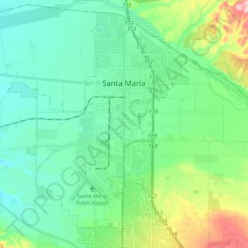
Topografische kaart Santa Maria
Interactieve kaart
Klik op de kaart om de hoogte weer te geven.
Over deze kaart
Naam: Topografische kaart Santa Maria, hoogte, reliëf.
Gemiddelde hoogte: 86 m
Minimale hoogte: 30 m
Maximale hoogte: 271 m
Andere topografische kaarten
Klik op een kaart om zijn topografie, zijn hoogte en zijn reliëf te bekijken.
Goleta
United States > California > Santa Barbara County
Goleta, Santa Barbara County, California, 93117, United States
Gemiddelde hoogte: 57 m
Gaffney Park
United States > California > Santa Barbara County > Isla Vista
Gaffney Park, 68 Block, Isla Vista, Santa Barbara County, California, United States
Gemiddelde hoogte: 6 m
Montecito
United States > California > Santa Barbara County
Montecito, Santa Barbara County, CAL Fire Southern Region, California, 93108, United States
Gemiddelde hoogte: 216 m
Vandenberg AFB
United States > California > Santa Barbara County > Vandenberg AFB
Vandenberg AFB, Santa Barbara County, CAL Fire Southern Region, California, 93437, United States
Gemiddelde hoogte: 124 m
Old Town
United States > California > Santa Barbara County > Carpinteria
Old Town, Carpinteria, Santa Barbara County, CAL Fire Southern Region, California, 93013, United States
Gemiddelde hoogte: 26 m
Gaviota
United States > California > Santa Barbara County
Gaviota, Santa Barbara County, CAL Fire Southern Region, California, United States
Gemiddelde hoogte: 82 m
Lions Head
United States > California > Santa Barbara County
Lions Head, Santa Barbara County, CAL Fire Southern Region, California, United States
Gemiddelde hoogte: 65 m