
Topografische kaart Annur
Interactieve kaart
Klik op de kaart om de hoogte weer te geven.
Over deze kaart
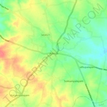
Naam: Topografische kaart Annur, hoogte, reliëf.
Gemiddelde hoogte: 381 m
Minimale hoogte: 356 m
Maximale hoogte: 412 m
Annur is located at 11°14′N 77°08′E / 11.23°N 77.13°E / 11.23; 77.13. It has an average elevation of 338 metres (1108 feet). Annur is well connected by roads including the National Highway 209 (New NH948) (Coimbatore to Bangalore highway) and the State Highway 80 SH80 Avanashi to Mettupalayam passes through Annur.
Andere topografische kaarten
Klik op een kaart om zijn topografie, zijn hoogte en zijn reliëf te bekijken.
Coimbatore
India > Tamil Nadu > Coimbatore North
Coimbatore, Coimbatore North, Coimbatore District, Tamil Nadu, 641001, India
Gemiddelde hoogte: 452 m
Somayampalayam
India > Tamil Nadu > Coimbatore North
Somayampalayam, Coimbatore North, Coimbatore District, Tamil Nadu, 641041, India
Gemiddelde hoogte: 471 m
Ward 19
India > Tamil Nadu > Coimbatore North > Coimbatore
Ward 19, West Zone, Coimbatore, Coimbatore North, Coimbatore District, Tamil Nadu, 641001, India
Gemiddelde hoogte: 435 m
Chinna Thadagam
India > Tamil Nadu > Coimbatore North > Chinna Thadagam
Chinna Thadagam, Coimbatore North, Coimbatore District, Tamil Nadu, 641108, India
Gemiddelde hoogte: 542 m
Kalapatti
India > Tamil Nadu > Coimbatore North > Kalapatti
Kalapatti, Coimbatore North, Coimbatore District, Tamil Nadu, 641048, India
Gemiddelde hoogte: 402 m
Veerapandi Pirivu
India > Tamil Nadu > Coimbatore North > Veerapandi Pirivu
Veerapandi Pirivu, Coimbatore North, Coimbatore District, Tamil Nadu, 641047, India
Gemiddelde hoogte: 417 m
Idigarai
India > Tamil Nadu > Coimbatore North > Idigarai
Idigarai, Coimbatore North, Coimbatore District, Tamil Nadu, 641020, India
Gemiddelde hoogte: 424 m
Chinnavedampatti
India > Tamil Nadu > Coimbatore North
Chinnavedampatti, Coimbatore North, Coimbatore District, Tamil Nadu, 641049, India
Gemiddelde hoogte: 428 m