
Topografische kaart Sri Muktsar Sahib
Interactieve kaart
Klik op de kaart om de hoogte weer te geven.
Over deze kaart
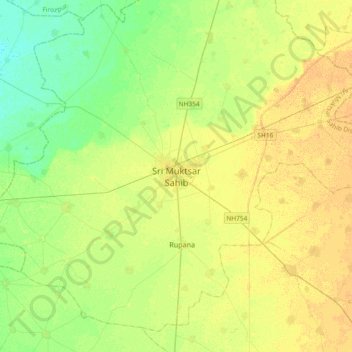
Naam: Topografische kaart Sri Muktsar Sahib, hoogte, reliëf.
Gemiddelde hoogte: 197 m
Minimale hoogte: 185 m
Maximale hoogte: 207 m
The average land elevation of the city is 648.52 feet (197.67 metres) above sea level. Lithologically, Muktsar is a part of the vast Indo-Gangetic alluvial plain, composed of alternate bands of sands, silt and clay with pebbles. Sandy plains, sand dunes and topographic depressions are the common landforms.