
Topografische kaart Crossville
Interactieve kaart
Klik op de kaart om de hoogte weer te geven.
Over deze kaart
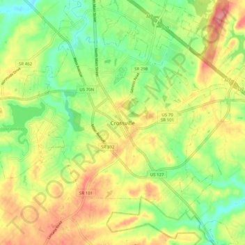
Naam: Topografische kaart Crossville, hoogte, reliëf.
Gemiddelde hoogte: 555 m
Minimale hoogte: 513 m
Maximale hoogte: 602 m
Crossville is located at the center of Cumberland County at 35°57′15″N 85°1′53″W / 35.95417°N 85.03139°W / 35.95417; -85.03139 (35.954221, -85.031267). The city is situated atop the Cumberland Plateau amidst the headwaters of the Obed River, which slices a gorge north of Crossville en route to its confluence with the Emory River to the northeast. Crossville is roughly halfway between the plateau's eastern escarpment along Walden Ridge and its western escarpment along the Highland Rim. Several small lakes are located on the outskirts of Crossville, including Lake Tansi to the south, Lake Holiday to the west, and Byrd Lake at nearby Cumberland Mountain State Park. The average elevation of Crossville is approximately 1,890 feet (580 m) above sea level.
Andere topografische kaarten
Klik op een kaart om zijn topografie, zijn hoogte en zijn reliëf te bekijken.
Meadowview
United States > Tennessee > Cumberland County > Crossville
Meadowview, Crossville, Cumberland County, East Tennessee, Tennessee, 37855, United States
Gemiddelde hoogte: 553 m
Port Haven
United States > Tennessee > Cumberland County > Crossville
Port Haven, Crossville, Cumberland County, Tennessee, 59300, United States
Gemiddelde hoogte: 549 m
Maplewood Estates
United States > Tennessee > Cumberland County > Crossville > Maplewood Estates
Maplewood Estates, Crossville, Cumberland County, Tennessee, 37855, United States
Gemiddelde hoogte: 553 m