
Topografische kaart Tabo
Interactieve kaart
Klik op de kaart om de hoogte weer te geven.
Over deze kaart
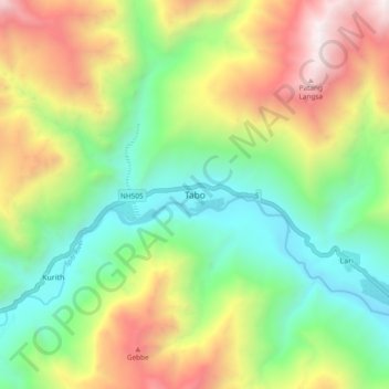
Naam: Topografische kaart Tabo, hoogte, reliëf.
Locatie: Tabo, Spiti, Lahul and Spiti, Himachal Pradesh, India (32.05396 78.34367 32.13396 78.42367)
Gemiddelde hoogte: 4.069 m
Minimale hoogte: 3.205 m
Maximale hoogte: 5.451 m
The village is situated at an altitude of 10,760 ft/ 3,280 metres. Climate in Tabo is very unpredictable as it ranges from cloudy to sunny and from snow to heavy snowfall. Summers are short from May to August and winters are longer from mid-September to April. Winter temperatures in Tabo can range from −15 °C (5 °F) in the day to −45 °C (−49 °F) overnight. In summers, temperature ranges from −5 °C (23 °F) at night to 20 °C (68 °F) celsius in daytime.
Andere topografische kaarten
Klik op een kaart om zijn topografie, zijn hoogte en zijn reliëf te bekijken.
Hikkim
India > Himachal Pradesh > Spiti > Hikkim
Hikkim, Spiti, Lahul and Spiti, Himachal Pradesh, India
Gemiddelde hoogte: 4.511 m
Kaza
India > Himachal Pradesh > Spiti
Kaza, Spiti, Lahul and Spiti, Himachal Pradesh, India
Gemiddelde hoogte: 4.161 m