
Topografische kaart The Thumb
Interactieve kaart
Klik op de kaart om de hoogte weer te geven.
Over deze kaart
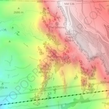
Naam: Topografische kaart The Thumb, hoogte, reliëf.
Gemiddelde hoogte: 2.771 m
Minimale hoogte: 2.165 m
Maximale hoogte: 3.247 m
Andere topografische kaarten
Klik op een kaart om zijn topografie, zijn hoogte en zijn reliëf te bekijken.
Rio Grande
United States of America > New Mexico > 475
Rio Grande, US 60, 475, Socorro County, New Mexico, United States of America
Gemiddelde hoogte: 1.502 m
Los Lunas
United States of America > New Mexico > Los Lunas
Los Lunas, Valencia County, New Mexico, 87130, United States of America
Gemiddelde hoogte: 1.523 m
Horse Mountain
United States of America > New Mexico
Horse Mountain, Grant County, New Mexico, United States of America
Gemiddelde hoogte: 1.840 m
Tolby Peak
United States of America > New Mexico
Tolby Peak, Colfax County, New Mexico, United States of America
Gemiddelde hoogte: 3.204 m
Cañon
United States of America > New Mexico > Cañon
Cañon, Sandoval County, New Mexico, 87024, United States of America
Gemiddelde hoogte: 1.785 m
La Canada
United States of America > New Mexico
La Canada, Rio Arriba County, New Mexico, United States of America
Gemiddelde hoogte: 2.458 m
Tekapo
United States of America > New Mexico > Tekapo
Tekapo, McKinley County, New Mexico, United States of America
Gemiddelde hoogte: 1.900 m
Sierra Alta
United States of America > New Mexico
Sierra Alta, Doña Ana County, New Mexico, United States of America
Gemiddelde hoogte: 1.561 m
Black Canyon
United States of America > New Mexico
Black Canyon, Socorro County, New Mexico, United States of America
Gemiddelde hoogte: 1.589 m