
Topografische kaart Hamburg
Interactieve kaart
Klik op de kaart om de hoogte weer te geven.
Over deze kaart
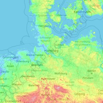
Naam: Topografische kaart Hamburg, hoogte, reliëf.
Locatie: Hamburg, Germany (50.98376 7.44991 56.10376 12.56991)
Gemiddelde hoogte: 56 m
Minimale hoogte: -6 m
Maximale hoogte: 1.074 m
The neighborhoods of Neuenfelde, Cranz, Francop and Finkenwerder are part of the Altes Land (old land) region, the largest contiguous fruit-producing region in Central Europe. Neugraben-Fischbek has Hamburg's highest elevation, the Hasselbrack at 116.2 metres (381 ft) AMSL. Hamburg borders the states of Schleswig-Holstein and Lower Saxony.