Topografische kaart Töll - Tel
Interactieve kaart
Klik op de kaart om de hoogte weer te geven.
Over deze kaart
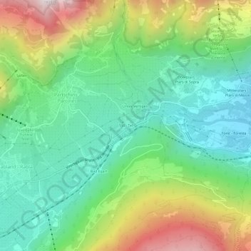
Naam: Topografische kaart Töll - Tel, hoogte, reliëf.
Gemiddelde hoogte: 770 m
Minimale hoogte: 356 m
Maximale hoogte: 1.582 m

Klik op de kaart om de hoogte weer te geven.
Naam: Topografische kaart Töll - Tel, hoogte, reliëf.
Gemiddelde hoogte: 770 m
Minimale hoogte: 356 m
Maximale hoogte: 1.582 m