
Topografische kaart Teutoburger Wald
Interactieve kaart
Klik op de kaart om de hoogte weer te geven.
Over deze kaart
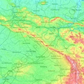
Naam: Topografische kaart Teutoburger Wald, hoogte, reliëf.
Gemiddelde hoogte: 105 m
Minimale hoogte: 31 m
Maximale hoogte: 462 m
Andere topografische kaarten
Klik op een kaart om zijn topografie, zijn hoogte en zijn reliëf te bekijken.
Stukenbrock
Duitsland > Noordrijn-Westfalen > Kreis Gütersloh > Schloß Holte-Stukenbrock
Stukenbrock, Schloß Holte-Stukenbrock, Kreis Gütersloh, Noordrijn-Westfalen, 33758, Duitsland
Gemiddelde hoogte: 135 m
Gütersloh
Duitsland > Noordrijn-Westfalen > Kreis Gütersloh
Gütersloh, Kreis Gütersloh, Noordrijn-Westfalen, Duitsland
Gemiddelde hoogte: 80 m
Halle (Westf.)
Duitsland > Noordrijn-Westfalen > Kreis Gütersloh
Halle (Westf.), Kreis Gütersloh, Noordrijn-Westfalen, 33790, Duitsland
Gemiddelde hoogte: 125 m
Rietberg
Duitsland > Noordrijn-Westfalen > Kreis Gütersloh > Rietberg > Rietberg
Rietberg, Kreis Gütersloh, Noordrijn-Westfalen, 33397, Duitsland
Gemiddelde hoogte: 80 m