
Topografische kaart Acapulco
Interactieve kaart
Klik op de kaart om de hoogte weer te geven.
Acapulco
The city, located on the Pacific coast of Mexico in the state of Guerrero, is classified as one of the state's seven regions, dividing the rest of the Guerrero coast into the Costa Grande and the Costa Chica. Forty percent of the municipality is mountainous terrain; another forty percent is semi-flat; and the other twenty percent is flat. Elevation varies from sea level to 1,699 metres (5,574 feet). The highest peaks are Potrero, San Nicolas, and Alto Camarón. One major river runs through the municipality, the Papagayo, along with a number of arroyos (streams). There are also two small lagoons, Tres Palos and Coyuca, along with a number of thermal springs.
Over deze kaart
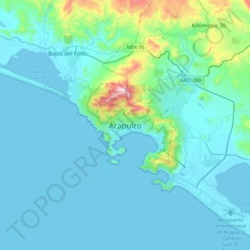
Naam: Topografische kaart Acapulco, hoogte, reliëf.
Locatie: Acapulco, Acapulco de Juárez, Guerrero, 39300, Mexico (16.70805 -100.05402 17.02805 -99.73402)
Gemiddelde hoogte: 99 m
Minimale hoogte: -2 m
Maximale hoogte: 932 m
Andere topografische kaarten
Klik op een kaart om zijn topografie, zijn hoogte en zijn reliëf te bekijken.
Centro Internacional Acapulco
Mexico > Guerrero > Acapulco de Juárez > Acapulco
Gemiddelde hoogte: 68 m