
Topografische kaart Fletcher
Interactieve kaart
Klik op de kaart om de hoogte weer te geven.
Over deze kaart
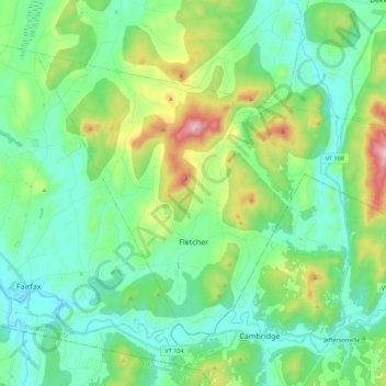
Naam: Topografische kaart Fletcher, hoogte, reliëf.
Locatie: Fletcher, Franklin County, Vermont, 05448, United States (44.64571 -73.00471 44.76055 -72.78366)
Gemiddelde hoogte: 229 m
Minimale hoogte: 103 m
Maximale hoogte: 610 m
Fletcher is located in southern Franklin County, bordered to the southeast by Lamoille County. According to the United States Census Bureau, the town has a total area of 38.0 square miles (98.4 km2), of which 37.7 square miles (97.7 km2) is land and 0.3 square miles (0.7 km2), or 0.71%, is water. The Lamoille River forms the short southern boundary of the town. Metcalf Pond is located in the north-central part of town. Fletcher Mountain, with a summit elevation of 2,150 feet (660 m), is located at the eastern end of town.
Andere topografische kaarten
Klik op een kaart om zijn topografie, zijn hoogte en zijn reliëf te bekijken.
Fairfield
United States > Vermont > Franklin County
Fairfield, Franklin County, Vermont, 05455, United States
Gemiddelde hoogte: 215 m
Sanderson Corner
United States > Vermont > Franklin County > Fairfax
Sanderson Corner, Fairfax, Franklin County, Vermont, United States
Gemiddelde hoogte: 165 m
Montgomery
United States > Vermont > Franklin County
Montgomery, Franklin County, Vermont, United States
Gemiddelde hoogte: 428 m
Saint Albans
United States > Vermont > Franklin County
Saint Albans, Franklin County, Vermont, United States
Gemiddelde hoogte: 143 m
Coombs Hill
United States > Vermont > Franklin County > Fletcher
Coombs Hill, Fletcher, Franklin County, Vermont, 05448, United States
Gemiddelde hoogte: 372 m
Enosburg Center
United States > Vermont > Franklin County > Enosburg > Enosburg Center
Enosburg Center, Enosburg, Franklin County, Vermont, 05450, United States
Gemiddelde hoogte: 231 m
Franklin County
United States > Vermont > Franklin County
Franklin County, Vermont, United States
Gemiddelde hoogte: 233 m