
Topografische kaart Dennison
Interactieve kaart
Klik op de kaart om de hoogte weer te geven.
Over deze kaart
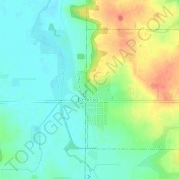
Naam: Topografische kaart Dennison, hoogte, reliëf.
Locatie: Dennison, Goodhue County, Minnesota, United States (44.39977 -93.04210 44.41788 -93.01984)
Gemiddelde hoogte: 303 m
Minimale hoogte: 285 m
Maximale hoogte: 334 m
Andere topografische kaarten
Klik op een kaart om zijn topografie, zijn hoogte en zijn reliëf te bekijken.
Zumbrota
United States > Minnesota > Goodhue County
Zumbrota, Goodhue County, Minnesota, 55992, United States
Gemiddelde hoogte: 312 m
Kenyon
United States > Minnesota > Goodhue County
Kenyon, Goodhue County, Minnesota, United States
Gemiddelde hoogte: 351 m
Frontenac
United States > Minnesota > Goodhue County
Frontenac, Florence Township, Goodhue County, Minnesota, 55026, United States
Gemiddelde hoogte: 243 m
Red Wing
United States > Minnesota > Goodhue County
Red Wing, Goodhue County, Minnesota, United States
Gemiddelde hoogte: 263 m
Goodhue
United States > Minnesota > Goodhue County
Goodhue, Goodhue County, Minnesota, 55027, United States
Gemiddelde hoogte: 346 m
Wanamingo
United States > Minnesota > Goodhue County
Wanamingo, Goodhue County, Minnesota, 55983, United States
Gemiddelde hoogte: 325 m
Pine Island
United States > Minnesota > Goodhue County
Pine Island, Goodhue County, Minnesota, United States
Gemiddelde hoogte: 327 m
Welch
United States > Minnesota > Goodhue County
Welch, Welch Township, Goodhue County, Minnesota, United States
Gemiddelde hoogte: 277 m
Cannon Falls
United States > Minnesota > Goodhue County > Cannon Falls > Cannon Falls
Cannon Falls, Goodhue County, Minnesota, 55009, United States
Gemiddelde hoogte: 268 m
Cannon Falls
United States > Minnesota > Goodhue County
Cannon Falls, Goodhue County, Minnesota, 55009, United States
Gemiddelde hoogte: 276 m