
Topografische kaart Illanoona
Interactieve kaart
Klik op de kaart om de hoogte weer te geven.
Over deze kaart
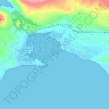
Naam: Topografische kaart Illanoona, hoogte, reliëf.
Gemiddelde hoogte: 20 m
Minimale hoogte: -1 m
Maximale hoogte: 127 m
Andere topografische kaarten
Klik op een kaart om zijn topografie, zijn hoogte en zijn reliëf te bekijken.
Inishowen
Inishowen, Neale Electoral Division, Claremorris-Swinford Municipal District, County Mayo, Connacht, Ireland
Gemiddelde hoogte: 18 m
Tawnyinah Upper
Tawnyinah Upper, Kilbeagh ED, Claremorris-Swinford Municipal District, County Mayo, Connacht, Ireland
Gemiddelde hoogte: 121 m
Killala
Killala, Kilalla ED, Ballina Municipal District, County Mayo, Connacht, Ireland
Gemiddelde hoogte: 21 m
Saleen
Saleen, Hollymount Electoral Division, Claremorris-Swinford Municipal District, County Mayo, Connacht, Ireland
Gemiddelde hoogte: 34 m
Ballindine
Ballindine, Claremorris-Swinford Municipal District, County Mayo, Connacht, Ireland
Gemiddelde hoogte: 62 m
Knock
Knock, Claremorris-Swinford Municipal District, County Mayo, Connacht, F12 KF89, Ireland
Gemiddelde hoogte: 94 m
Ballina Municipal District
Ballina Municipal District, County Mayo, Connacht, Ireland
Gemiddelde hoogte: 74 m
Castlebar
Castlebar, Castlebar Municipal District, County Mayo, Connacht, Ireland
Gemiddelde hoogte: 44 m
Westport-Belmullet Municipal District
Westport-Belmullet Municipal District, County Mayo, Connacht, Ireland, Croaghaun
Gemiddelde hoogte: 275 m
Cloghans
Cloghans, Carrowmore ED, Ballina Municipal District, County Mayo, Connacht, Ireland
Gemiddelde hoogte: 14 m
Oory
Oory, Cloghermore Electoral Division, Claremorris-Swinford Municipal District, County Mayo, Connacht, Ireland
Gemiddelde hoogte: 47 m
Claremorris-Swinford Municipal District
Claremorris-Swinford Municipal District, County Mayo, Connacht, Ireland
Gemiddelde hoogte: 69 m
Clare Island
Clare Island, Westport-Belmullet Municipal District, County Mayo, Connacht, Ireland
Gemiddelde hoogte: 29 m
Garrankeel
Garrankeel, Ballina Rural ED, Ballina Municipal District, County Mayo, Connacht, Ireland
Gemiddelde hoogte: 20 m
Achill Island
Achill Island, County Mayo, Connacht, F28 X018, Ireland
Gemiddelde hoogte: 42 m
Westport-Belmullet Municipal District
Westport-Belmullet Municipal District, County Mayo, Connacht, Ireland
Gemiddelde hoogte: 62 m
Mayo
Mayo, Claremorris-Swinford Municipal District, County Mayo, Connacht, F12 E7W7, Ireland
Gemiddelde hoogte: 53 m
Mount Eagle
Mount Eagle, Westport-Belmullet Municipal District, County Mayo, Connacht, Ireland
Gemiddelde hoogte: 274 m
Ballinglen
Ballinglen, Ballycastle ED, Ballina Municipal District, County Mayo, Connacht, Ireland
Gemiddelde hoogte: 117 m
Castlebar
Ireland > County Mayo > Castlebar
Castlebar, Castlebar Municipal District, County Mayo, Connacht, F23 DP02, Ireland
Gemiddelde hoogte: 56 m
Ballinrobe
Ireland > County Mayo > Ballinrobe
Ballinrobe, Claremorris-Swinford Municipal District, County Mayo, Connacht, F31 Y865, Ireland
Gemiddelde hoogte: 32 m
Shrule
Ireland > County Mayo > Shrule
Shrule, Claremorris-Swinford Municipal District, County Mayo, Connacht, Ireland
Gemiddelde hoogte: 35 m
Swineford
Swineford, Swineford Electoral Division, Claremorris-Swinford Municipal District, County Mayo, Connacht, Ireland
Gemiddelde hoogte: 65 m
Croagh Patrick
Croagh Patrick, Westport-Belmullet Municipal District, County Mayo, Connacht, Ireland
Gemiddelde hoogte: 314 m
Westport
Ireland > County Mayo > Westport
Westport, Westport-Belmullet Municipal District, County Mayo, Connacht, F28 RD39, Ireland
Gemiddelde hoogte: 40 m
Claremorris
Ireland > County Mayo > Claremorris
Claremorris, Claremorris-Swinford Municipal District, County Mayo, Connacht, F12 RY11, Ireland
Gemiddelde hoogte: 67 m
Belmullet
Ireland > County Mayo > Belmullet
Belmullet, Westport-Belmullet Municipal District, County Mayo, Connacht, Ireland
Gemiddelde hoogte: 14 m
Lecarrow
Lecarrow, Knock North Electoral Division, Claremorris-Swinford Municipal District, County Mayo, Connacht, Ireland
Gemiddelde hoogte: 83 m
Kilmovee
Ireland > County Mayo > Kilmovee
Kilmovee, Claremorris-Swinford Municipal District, County Mayo, Connacht, Ireland
Gemiddelde hoogte: 104 m
Carrowmore
Carrowmore, Cloghermore Electoral Division, Claremorris-Swinford Municipal District, County Mayo, Connacht, Ireland
Gemiddelde hoogte: 48 m
Ballindine
Ireland > County Mayo > Ballindine
Ballindine, Claremorris-Swinford Municipal District, County Mayo, Connacht, Ireland
Gemiddelde hoogte: 61 m
Milford Demesne
Milford Demesne, Dalgan Electoral Division, Claremorris-Swinford Municipal District, County Mayo, Connacht, Ireland
Gemiddelde hoogte: 36 m
Newport
Ireland > County Mayo > Newport
Newport, Westport-Belmullet Municipal District, County Mayo, Connacht, Ireland
Gemiddelde hoogte: 23 m
Drumbaun
Drumbaun, Ballyhaunis ED, Claremorris-Swinford Municipal District, County Mayo, Connacht, Ireland
Gemiddelde hoogte: 77 m
Brickeens
Brickeens, Culnacleha Electoral Division, Claremorris-Swinford Municipal District, County Mayo, Connacht, Ireland
Gemiddelde hoogte: 71 m
Derrypark
Derrypark, Owenbrin Electoral Division, Castlebar Municipal District, County Mayo, Connacht, Ireland
Gemiddelde hoogte: 46 m
Derrymore
Derrymore, Coonard Electoral Division, Claremorris-Swinford Municipal District, County Mayo, Connacht, Ireland
Gemiddelde hoogte: 45 m
Bangor
Ireland > County Mayo > Bangor
Bangor, Westport-Belmullet Municipal District, County Mayo, Connacht, Ireland
Gemiddelde hoogte: 71 m
Benmore
Benmore, Westport-Belmullet Municipal District, County Mayo, Connacht, Ireland
Gemiddelde hoogte: 119 m
Castlehill
Castlehill, Crossmolina South ED, Ballina Municipal District, County Mayo, Connacht, Ireland
Gemiddelde hoogte: 19 m
Glenavenew
Glenavenew, Addergoole ED, Castlebar Municipal District, County Mayo, Connacht, Ireland
Gemiddelde hoogte: 82 m
Knock
Ireland > County Mayo > Knock
Knock, Claremorris-Swinford Municipal District, County Mayo, Connacht, F12KF89, Ireland
Gemiddelde hoogte: 87 m