
Topografische kaart Xi'an
Interactieve kaart
Klik op de kaart om de hoogte weer te geven.
Over deze kaart
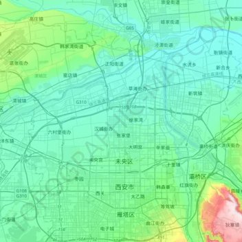
Naam: Topografische kaart Xi'an, hoogte, reliëf.
Locatie: Xi'an, Shaanxi, 710018, China (34.18305 108.77508 34.50305 109.09508)
Gemiddelde hoogte: 412 m
Minimale hoogte: 350 m
Maximale hoogte: 778 m
Xi'an lies on the Guanzhong Plain in the south-central part of Shaanxi province, on a flood plain created by the eight surrounding rivers and streams. The city has an average elevation of 400 metres (1,312 ft) above sea level and an annual precipitation of 553 mm (21.8 in). The urban area of Xi'an is located at 34°16′N 108°56′E / 34.267°N 108.933°E / 34.267; 108.933. The Wei River provides potable water to the city.