
Topografische kaart Dąbrowa Białostocka
Interactieve kaart
Klik op de kaart om de hoogte weer te geven.
Over deze kaart
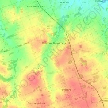
Naam: Topografische kaart Dąbrowa Białostocka, hoogte, reliëf.
Gemiddelde hoogte: 153 m
Minimale hoogte: 120 m
Maximale hoogte: 178 m
Andere topografische kaarten
Klik op een kaart om zijn topografie, zijn hoogte en zijn reliëf te bekijken.
Jelenia Góra
Poland > Podlaskie Voivodeship > Sokółka County
Jelenia Góra, gmina Sokółka, Sokółka County, Podlaskie Voivodeship, Poland
Gemiddelde hoogte: 166 m
Ostra Góra
Poland > Podlaskie Voivodeship > Sokółka County > Ostra Góra
Ostra Góra, gmina Korycin, Sokółka County, Podlaskie Voivodeship, Poland
Gemiddelde hoogte: 166 m
Stock
Poland > Podlaskie Voivodeship > Sokółka County
Stock, gmina Dąbrowa Białostocka, Sokółka County, Podlaskie Voivodeship, Poland
Gemiddelde hoogte: 151 m
Sokółka
Poland > Podlaskie Voivodeship > Sokółka County
Sokółka, gmina Sokółka, Sokółka County, Podlaskie Voivodeship, 16-100, Poland
Gemiddelde hoogte: 167 m
Popiołówka
Poland > Podlaskie Voivodeship > Sokółka County
Popiołówka, gmina Korycin, Sokółka County, Podlaskie Voivodeship, Poland
Gemiddelde hoogte: 149 m