
Doe een donatie
Rust jezelf uit voor je volgende avontuur:
Als Amazon-partner verdient deze site een commissie op in aanmerking komende aankopen, zonder extra kosten voor jou.
Topografische kaart Signal Hill
Klik op de kaart om de hoogte weer te geven.
Doe een donatie
Rust jezelf uit voor je volgende avontuur:
Als Amazon-partner verdient deze site een commissie op in aanmerking komende aankopen, zonder extra kosten voor jou.
Signal Hill
Signal Hill (Maori: Te Pahuri o te Rangipohika) is a prominent landform in the city of Dunedin, New Zealand. It is located close to, and due north of, the head of the Otago Harbour and reaches an elevation of 393 m (1289 ft). The suburbs Ravensbourne, St. Leonards, and Opoho lie on its southern, eastern, and northwestern flanks, respectively. To the northwest is North East Valley, the thalweg of Lindsay Creek, a tributary of the Water of Leith. The southernmost spur of Signal Hill, Logan Point, has been extensively quarried for road gravel. State Highway 88 skirts the foot of the hill close to the edge of the Otago Harbour.
Doe een donatie
Rust jezelf uit voor je volgende avontuur:
Als Amazon-partner verdient deze site een commissie op in aanmerking komende aankopen, zonder extra kosten voor jou.
Over deze kaart
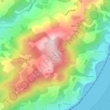
Naam: Topografische kaart Signal Hill, hoogte, reliëf.
Gemiddelde hoogte: 174 m
Minimale hoogte: 0 m
Maximale hoogte: 398 m
Doe een donatie
Rust jezelf uit voor je volgende avontuur:
Als Amazon-partner verdient deze site een commissie op in aanmerking komende aankopen, zonder extra kosten voor jou.