
Topografische kaart La Glace
Interactieve kaart
Klik op de kaart om de hoogte weer te geven.
Over deze kaart
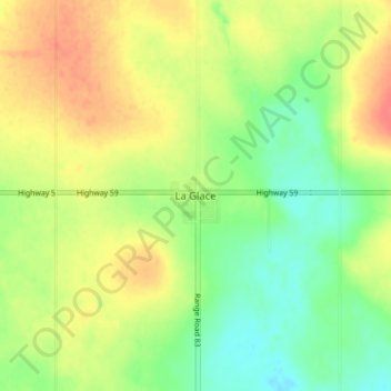
Naam: Topografische kaart La Glace, hoogte, reliëf.
Locatie: La Glace, Division No. 19, Alberta, T0H 2J0, Canada (55.38296 -119.17437 55.42296 -119.13437)
Gemiddelde hoogte: 738 m
Minimale hoogte: 713 m
Maximale hoogte: 764 m
La Glace is a hamlet in northern Alberta, Canada within the County of Grande Prairie No. 1. It is located along Highway 59 between Sexsmith and Valhalla Centre and has an elevation of 735 metres (2,411 ft).
Andere topografische kaarten
Klik op een kaart om zijn topografie, zijn hoogte en zijn reliëf te bekijken.
Clairmont
Canada > Alberta > Division No. 19 > Hamlet of Clairmont
Clairmont, Hamlet of Clairmont, Division No. 19, Alberta, T0H 0W0, Canada
Gemiddelde hoogte: 679 m
Village of Donnelly
Canada > Alberta > Division No. 19
Village of Donnelly, Division No. 19, Alberta, Canada
Gemiddelde hoogte: 594 m
Grande Prairie
Canada > Alberta > Division No. 19
Grande Prairie, Division No. 19, Alberta, Canada
Gemiddelde hoogte: 665 m
Beaverlodge
Canada > Alberta > Division No. 19
Beaverlodge, Division No. 19, Alberta, T0H 0C0, Canada
Gemiddelde hoogte: 735 m