
Topografische kaart Le Val du Pâtre
Interactieve kaart
Klik op de kaart om de hoogte weer te geven.
Over deze kaart
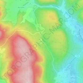
Naam: Topografische kaart Le Val du Pâtre, hoogte, reliëf.
Gemiddelde hoogte: 392 m
Minimale hoogte: 244 m
Maximale hoogte: 583 m
Andere topografische kaarten
Klik op een kaart om zijn topografie, zijn hoogte en zijn reliëf te bekijken.
Château Wagenbourg
France > Grand Est > Haut-Rhin > Soultzmatt
Château Wagenbourg, Rue de la Vallée, Soultzmatt, Thann-Guebwiller, Haut-Rhin, Grand Est, France métropolitaine, 68570, France
Gemiddelde hoogte: 335 m
Wintzfelden
France > Grand Est > Haut-Rhin > Soultzmatt
Wintzfelden, Soultzmatt, Thann-Guebwiller, Haut-Rhin, Grand Est, France métropolitaine, 68570, France
Gemiddelde hoogte: 490 m
Thannwiller
France > Grand Est > Haut-Rhin > Soultzmatt
Thannwiller, Soultzmatt, Thann-Guebwiller, Haut-Rhin, Grand Est, France métropolitaine, 68570, France
Gemiddelde hoogte: 442 m