
Topografische kaart Alta Vista
Interactieve kaart
Klik op de kaart om de hoogte weer te geven.
Over deze kaart
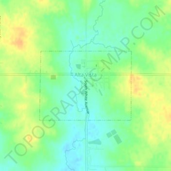
Naam: Topografische kaart Alta Vista, hoogte, reliëf.
Locatie: Alta Vista, Chickasaw County, Iowa, United States (43.19124 -92.42698 43.20217 -92.40704)
Gemiddelde hoogte: 360 m
Minimale hoogte: 346 m
Maximale hoogte: 377 m
Andere topografische kaarten
Klik op een kaart om zijn topografie, zijn hoogte en zijn reliëf te bekijken.
Fredericksburg
United States > Iowa > Chickasaw County
Fredericksburg, Chickasaw County, Iowa, United States
Gemiddelde hoogte: 333 m
North Washington
United States > Iowa > Chickasaw County
North Washington, Chickasaw County, Iowa, 50661, United States
Gemiddelde hoogte: 344 m
Ionia
United States > Iowa > Chickasaw County
Ionia, Chickasaw County, Iowa, United States
Gemiddelde hoogte: 345 m
Lawler
United States > Iowa > Chickasaw County
Lawler, Chickasaw County, Iowa, United States
Gemiddelde hoogte: 338 m
Nashua
United States > Iowa > Chickasaw County
Nashua, Chickasaw County, Iowa, United States
Gemiddelde hoogte: 302 m
Bassett
United States > Iowa > Chickasaw County
Bassett, Chickasaw County, Iowa, United States
Gemiddelde hoogte: 320 m
New Hampton
United States > Iowa > Chickasaw County
New Hampton, Chickasaw County, Iowa, 50659, United States
Gemiddelde hoogte: 349 m