
Topografische kaart June Lake
Interactieve kaart
Klik op de kaart om de hoogte weer te geven.
June Lake
June Lake is a census-designated place in Mono County, California. It is located against the southern rim of the Mono Basin, 12.5 miles (20 km) south of Lee Vining, at an elevation of 7654 feet (2333 m).
Over deze kaart
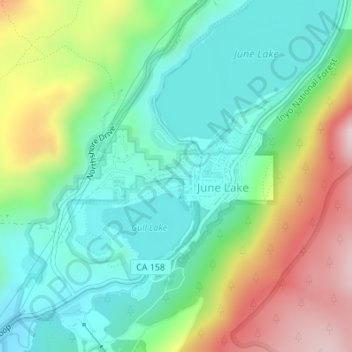
Naam: Topografische kaart June Lake, hoogte, reliëf.
Locatie: June Lake, Mono County, California, 93529, United States (37.77480 -119.08879 37.78380 -119.07132)
Gemiddelde hoogte: 2.445 m
Minimale hoogte: 2.284 m
Maximale hoogte: 2.764 m
Andere topografische kaarten
Klik op een kaart om zijn topografie, zijn hoogte en zijn reliëf te bekijken.
June Lake
United States > California > Mono County > June Lake
Because the community is built on hills and meadows in this subalpine valley surrounded by high mountain peaks, it has been dubbed the "Switzerland of California." The area is notable for its trout fishing. Hiking is a favorite pastime of the area: June Lake offers many trails that lead into the nearby back…
Gemiddelde hoogte: 2.531 m