
Topografische kaart Freising
Interactieve kaart
Klik op de kaart om de hoogte weer te geven.
Freising
In 1802/1803 Bavaria fell under the influence of Napoleonic France in which church controlled lands were secularized. In Freising, the more than thousand-year-old bishopric was abolished. The Roman Catholic Church lost most of its properties and authority over the city. Though the seat of the diocese was moved to Munich in 1821, including the elevation to an archdiocese, Freising has remained the seat of diocesan administration until today.
Over deze kaart
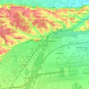
Naam: Topografische kaart Freising, hoogte, reliëf.
Locatie: Freising, Landkreis Freising, Bavaria, Germany (48.33061 11.64045 48.44903 11.79251)
Gemiddelde hoogte: 457 m
Minimale hoogte: 419 m
Maximale hoogte: 522 m
Andere topografische kaarten
Klik op een kaart om zijn topografie, zijn hoogte en zijn reliëf te bekijken.