
Topografische kaart San Rafael
Interactieve kaart
Klik op de kaart om de hoogte weer te geven.
Over deze kaart
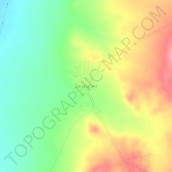
Naam: Topografische kaart San Rafael, hoogte, reliëf.
Locatie: San Rafael, Villa de Ramos, San Luis Potosí, México (23.00212 -101.96460 23.04212 -101.92460)
Gemiddelde hoogte: 2.157 m
Minimale hoogte: 2.110 m
Maximale hoogte: 2.211 m
Andere topografische kaarten
Klik op een kaart om zijn topografie, zijn hoogte en zijn reliëf te bekijken.
El Barril
México > San Luis Potosí > Villa de Ramos > El Barril
El Barril, Villa de Ramos, San Luis Potosí, México
Gemiddelde hoogte: 1.985 m