
Topografische kaart Monongahela National Forest
Interactieve kaart
Klik op de kaart om de hoogte weer te geven.
Over deze kaart
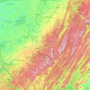
Naam: Topografische kaart Monongahela National Forest, hoogte, reliëf.
Gemiddelde hoogte: 655 m
Minimale hoogte: 191 m
Maximale hoogte: 1.474 m
In 1943 and 1944, as part of the West Virginia Maneuver Area, the U.S. Army used parts of the Monongahela National Forest as a practice artillery and mortar range and maneuver area before troops were sent to Europe to fight in World War II. Artillery and mortar shells shot into the area for practice are still occasionally found there today. Seneca Rocks and other area cliffs were also used for assault climbing instruction. This was the Army's only low-altitude climbing school.
Andere topografische kaarten
Klik op een kaart om zijn topografie, zijn hoogte en zijn reliëf te bekijken.
Denmar
United States > West Virginia > Pocahontas County
Denmar, Pocahontas County, West Virginia, 24946, United States
Gemiddelde hoogte: 690 m
Green Bank Telescope
United States > West Virginia > Pocahontas County
Green Bank Telescope, Slavin Hollow Road, Pocahontas County, West Virginia, 24944, United States
Gemiddelde hoogte: 822 m
Marlinton
United States > West Virginia > Pocahontas County > Marlinton
Marlinton, Pocahontas County, West Virginia, 24924, United States
Gemiddelde hoogte: 791 m
Hillsboro
United States > West Virginia > Pocahontas County > Hillsboro
Hillsboro, Pocahontas County, West Virginia, United States
Gemiddelde hoogte: 706 m
Walnut
United States > West Virginia > Pocahontas County > Walnut
Walnut, Pocahontas County, West Virginia, 26291, United States
Gemiddelde hoogte: 1.041 m
Frank
United States > West Virginia > Pocahontas County
Frank, Pocahontas County, West Virginia, 26264, United States
Gemiddelde hoogte: 926 m
Cass
United States > West Virginia > Pocahontas County > Cass
Cass, Pocahontas County, West Virginia, United States
Gemiddelde hoogte: 839 m