Geolokaliseren

Topografische kaart Saint-Denis

Interactieve kaart

Klik op de kaart om de hoogte weer te geven.

Over deze kaart

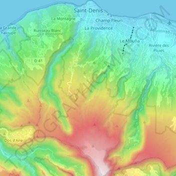
Naam: Topografische kaart Saint-Denis, hoogte, reliëf.

Locatie: Saint-Denis, Réunion, France (-21.01505 55.37563 -20.87174 55.51269)

Gemiddelde hoogte: 722 m

Minimale hoogte: 0 m

Maximale hoogte: 2.266 m

The city is located on the north end of the island, and was a port. Saint-Denis was "originally the main port of Réunion, but an artificial harbour at Le Port, on the northwest coast, replaced it in the 1880s, because of unpredictable winds and tides at Saint-Denis." The city includes some of the island's mountains, with a peak elevation of 2,276 meters (7,467 ft) within the metro area, which begins at sea level at the coast line.

Wikipedia (CC-BY-SA 3.0)

Andere topografische kaarten

Klik op een kaart om zijn topografie, zijn hoogte en zijn reliëf te bekijken.

Réunion

France > Réunion

Réunion, France

Gemiddelde hoogte: 532 m

Sainte-Rose

France > Réunion

Sainte-Rose, Saint-Benoît, Réunion, 97439, France

Gemiddelde hoogte: 505 m

Saint-Benoît

France > Réunion

Saint-Benoît, Réunion, France

Gemiddelde hoogte: 561 m

échelles

France > Réunion > Saint-Benoît

échelles, Sentier de Takamaka, Saint-Benoît, Réunion, 97431, France

Gemiddelde hoogte: 1.008 m

Réunion

France > Réunion

Réunion, France

Gemiddelde hoogte: 532 m

Marla

France > Réunion > Saint-Paul > Marla

Marla, Saint-Paul, Réunion, France

Gemiddelde hoogte: 1.798 m

Hell Bourg

France > Réunion > Hell Bourg

Hell-Bourg, Hell Bourg, Saint-Benoît, Réunion, 97433, France

Gemiddelde hoogte: 1.132 m

Cayenne

France > Réunion > La Possession > Cayenne

Cayenne, La Possession, Saint-Paul, Réunion, 97419, France

Gemiddelde hoogte: 916 m

Saint-Leu

France > Réunion > Saint-Leu

Saint-Leu, Saint-Paul, Réunion, France

Gemiddelde hoogte: 360 m

Saint-Benoît

France > Réunion > Saint-Benoît > Saint-Benoît

Saint-Benoît, Réunion, 97470, France

Gemiddelde hoogte: 50 m

Terre Sainte

France > Réunion > Saint-Pierre > Terre Sainte

Terre Sainte, Saint-Pierre, Réunion, 97410, France

Gemiddelde hoogte: 50 m

La Petite Ferme

France > Réunion > Le Tampon > La Petite Ferme

La Petite Ferme, Le Tampon, Saint-Pierre, Réunion, 97418, France

Gemiddelde hoogte: 1.522 m

La Réunion

France > Réunion

La Réunion, Réunion, France

Gemiddelde hoogte: 532 m

Caverne Dufour

France > Réunion > Salazie

Caverne Dufour, Chemin du Piton des Neiges, Trou Blanc, Salazie, Saint-Benoît, Réunion, 97433, France

Gemiddelde hoogte: 2.217 m

Le Tampon

France > Réunion > Le Tampon

Le Tampon, Saint-Pierre, Réunion, France

Gemiddelde hoogte: 1.005 m

Le Port

France > Réunion > Le Port

Le Port, Saint-Paul, Réunion, 97420, France

Gemiddelde hoogte: 25 m

Saint-Pierre

France > Réunion > Saint-Pierre

Saint-Pierre, Réunion, France

Gemiddelde hoogte: 327 m

Cap Blanc

France > Réunion > Saint-Joseph

Cap Blanc, Saint-Joseph, Saint-Pierre, Réunion, 97480, France

Gemiddelde hoogte: 1.176 m

Saint-André

France > Réunion > Saint-André

Saint-André, Saint-Benoît, Réunion, 97440, France

Gemiddelde hoogte: 125 m

Saint-Paul

France > Réunion

Saint-Paul, Réunion, France

Gemiddelde hoogte: 466 m

Saint-Philippe

France > Réunion > Saint-Philippe

Saint-Philippe, Saint-Pierre, Réunion, 97442, France

Gemiddelde hoogte: 663 m

La Possession

France > Réunion > La Possession

La Possession, Saint-Paul, Réunion, 97419, France

Gemiddelde hoogte: 605 m

Piton de la Fournaise

France > Réunion > Sainte-Rose

Piton de la Fournaise, Sainte-Rose, Saint-Benoît, Réunion, 97439, France

Gemiddelde hoogte: 2.255 m