
Topografische kaart Winter Park
Interactieve kaart
Klik op de kaart om de hoogte weer te geven.
Over deze kaart
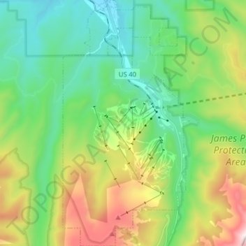
Naam: Topografische kaart Winter Park, hoogte, reliëf.
Locatie: Winter Park, Grand County, Colorado, United States (39.83223 -105.81202 39.93046 -105.74783)
Gemiddelde hoogte: 3.068 m
Minimale hoogte: 2.653 m
Maximale hoogte: 3.994 m
Its elevation ranges from approximately 8,700 to 12,060 feet (2,650 to 3,680 m) above sea level, and is considered sub-alpine country. It is snow-covered for about six months a year. Although the town center is at about 9,000 feet (2,700 m) above sea level, Winter Park, using administrative boundaries as a measure, became the highest incorporated town in the United States after the July 2006 annexation of 5,214 acres (21.10 km2) of Winter Park Resort to allow new on-mountain improvements. This claim is disputed since Winter Park has no residences above 9,550 feet (2,910 m), while contiguous residential neighborhoods in Leadville, Colorado, extend to 10,360 feet (3,160 m) and in Alma, Colorado, to 11,680 feet (3,560 m), and Alma's town center is at 10,361 feet (3,158 m).
Andere topografische kaarten
Klik op een kaart om zijn topografie, zijn hoogte en zijn reliëf te bekijken.
Grand Lake
United States > Colorado > Grand County
Grand Lake, Grand County, Colorado, United States
Gemiddelde hoogte: 2.630 m
Morse Mountain
United States > Colorado > Grand County
Morse Mountain, Grand County, Colorado, United States
Gemiddelde hoogte: 2.924 m
Fraser
United States > Colorado > Grand County
Fraser, Grand County, Colorado, 80442, United States
Gemiddelde hoogte: 2.696 m
Lake Granby
United States > Colorado > Grand County
Lake Granby, Grand County, Colorado, United States
Gemiddelde hoogte: 2.608 m
Granby
United States > Colorado > Grand County
Granby, Grand County, Colorado, United States
Gemiddelde hoogte: 2.555 m
Rabbit Ears Pass
United States > Colorado > Grand County
Rabbit Ears Pass, Grand County, Colorado, United States
Gemiddelde hoogte: 2.852 m
Bottle Peak
United States > Colorado > Grand County
Bottle Peak, Grand County, Colorado, United States
Gemiddelde hoogte: 3.283 m
Elk Mountain
United States > Colorado > Grand County
Elk Mountain, Grand County, Colorado, United States
Gemiddelde hoogte: 3.218 m
Tabernash
United States > Colorado > Grand County
Tabernash, Grand County, Colorado, 80478, United States
Gemiddelde hoogte: 2.592 m
Kremmling
United States > Colorado > Grand County
Kremmling, Grand County, Colorado, 80459, United States
Gemiddelde hoogte: 2.251 m
Mount Flora
United States > Colorado > Grand County
Mount Flora, Grand County, Colorado, United States
Gemiddelde hoogte: 3.728 m
Indian Peaks Wilderness
United States > Colorado > Grand County
Indian Peaks Wilderness, Grand County, Colorado, United States
Gemiddelde hoogte: 3.080 m