
Topografische kaart Bixby
Interactieve kaart
Klik op de kaart om de hoogte weer te geven.
Over deze kaart
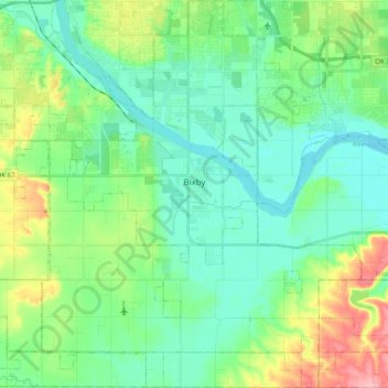
Naam: Topografische kaart Bixby, hoogte, reliëf.
Locatie: Bixby, Tulsa County, Oklahoma, 74008, United States (35.85590 -95.96185 36.01728 -95.76210)
Gemiddelde hoogte: 204 m
Minimale hoogte: 171 m
Maximale hoogte: 294 m
Bixby is located at 35°57′39″N 95°52′42″W / 35.96083°N 95.87833°W / 35.96083; -95.87833 (35.960898, −95.878258). According to the United States Census Bureau, the city has a total area of 25.1 square miles (65.0 km2), of which 24.0 square miles (62.3 km2) is land and 1.0 square mile (2.7 km2) (4.15%) is water. The average elevation is 750 ft (230 m) above MSL. The town is bisected into north and south portions by the Arkansas River; the original town center is located south of the river.
Andere topografische kaarten
Klik op een kaart om zijn topografie, zijn hoogte en zijn reliëf te bekijken.
Sand Springs
United States > Oklahoma > Tulsa County
Sand Springs, Tulsa County, Oklahoma, United States
Gemiddelde hoogte: 238 m
Jenks
United States > Oklahoma > Tulsa County
Jenks, Tulsa County, Oklahoma, 74037, United States
Gemiddelde hoogte: 205 m
Broken Arrow
United States > Oklahoma > Tulsa County
Broken Arrow, Tulsa County, Oklahoma, United States
Gemiddelde hoogte: 205 m
Collinsville
United States > Oklahoma > Tulsa County
Collinsville, Tulsa County, Oklahoma, United States
Gemiddelde hoogte: 197 m
Tulsa
United States > Oklahoma > Tulsa County
Tulsa, Tulsa County, Oklahoma, United States
Gemiddelde hoogte: 221 m
Owasso
United States > Oklahoma > Tulsa County
Owasso, Tulsa County, Oklahoma, 74055, United States
Gemiddelde hoogte: 199 m
Southern Reserve
United States > Oklahoma > Tulsa County > Jenks
Southern Reserve, Jenks, Tulsa County, Oklahoma, United States
Gemiddelde hoogte: 197 m