
Topografische kaart Pangong Tso
Interactieve kaart
Klik op de kaart om de hoogte weer te geven.
Over deze kaart
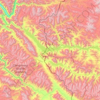
Naam: Topografische kaart Pangong Tso, hoogte, reliëf.
Locatie: Pangong Tso, Rutog County, Ngari Prefecture, Tibet, China (33.42971 78.41971 33.98425 79.93191)
Gemiddelde hoogte: 5.119 m
Minimale hoogte: 3.493 m
Maximale hoogte: 6.599 m
Pangong Tso or Pangong Lake (Tibetan: སྤང་གོང་མཚོ; Chinese: 班公错, Pinyin: Bān gōng cuò, Hindi: पैंगोंग झील) is an endorheic lake in the Himalayas situated at an elevation of 4,225 m (13,862 ft). It is 134 km (83 mi) long and extends from Ladakh, India to the Tibetan Autonomous Region, China. Approximately 60% of the length of the lake lies within the Tibetan Autonomous Region. The lake is 5 km (3.1 mi) wide at its broadest point. All together it covers 604 km2. During winter the lake freezes completely, despite being saline water. It is not a part of the Indus River basin area and geographically a separate landlocked river basin.
Andere topografische kaarten
Klik op een kaart om zijn topografie, zijn hoogte en zijn reliëf te bekijken.
Kunlun Mountains
China > Tibet > Rutog County > Dongru
Kunlun Mountains, Dongru, Rutog County, Ngari Prefecture, Tibet, China
Gemiddelde hoogte: 6.188 m