
Topografische kaart Round Rock
Klik op de kaart om de hoogte weer te geven.
Round Rock
Round Rock sits at an approximate elevation of 735 feet above sea level and spans a diverse terrain shaped by the Balcones Escarpment. This geological fault line divides the city into two distinct landscapes: the eastern side lies on the relatively flat and fertile Blackland Prairie, characterized by deep, clay-rich soils ideal for agriculture. In contrast, the western side features the rugged, limestone-rich topography of the Texas Hill Country, where rolling hills and exposed bedrock are common. This variance in elevation and terrain not only creates a unique visual landscape but also influences local ecosystems and land use across the city.
Over deze kaart
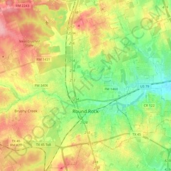
Naam: Topografische kaart Round Rock, hoogte, reliëf.
Locatie: Round Rock, Williamson County, Texas, United States (30.46829 -97.76484 30.59378 -97.59005)
Gemiddelde hoogte: 242 m
Minimale hoogte: 191 m
Maximale hoogte: 306 m
Andere topografische kaarten
Klik op een kaart om zijn topografie, zijn hoogte en zijn reliëf te bekijken.
Georgetown
United States > Texas > Williamson County > Georgetown
The city is located on the northeastern edge of Texas Hill Country. Portions of Georgetown are located on either side of the Balcones Escarpment, a fault line in which the areas roughly east of IH-35 are flat and characterized by having black, fertile soils of the Blackland Prairie, and the west side of the…
Gemiddelde hoogte: 228 m
Soil Conservation Service Site 12 Dam
United States > Texas > Williamson County > Type
Gemiddelde hoogte: 173 m
Soil Conservation Service Site 12 Dam
United States > Texas > Williamson County > Type
Gemiddelde hoogte: 173 m
Soil Conservation Service Site 12 Dam
United States > Texas > Williamson County > Type
Gemiddelde hoogte: 173 m